Winter Forecast - November 29 7 years ago
November 29, 2018
- Adjustments made to December forecast.
- All roads lead to February.
- 2002 analog continues to astound.
- The milder period from mid-December into early January is on the table.
- Overall the major signals remain and cold should retake control (if it even leaves).
Analog:
.png)
Snowfall remains the same (obviously we are off to a great start with snowfall so far):
.png)
Month-by Month
For December we are concerned about a warmup. The parallels to 2002 weigh heavily, but MJO considerations and the fact that over the past couple of months warmups have been blunted, give us pause. We knew the milder period was coming, but how long and how strong is the big conundrum. So the December forecast runs the risk of doing what we did in November, which was change a better long-standing forecast at the end.
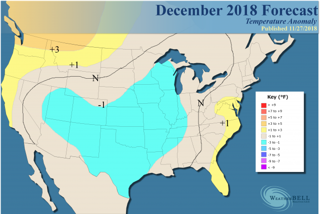
This is still a large area of cool, but not as cold as the -3°F core farther to the east that we had (in a more populated area). The sensible analog:
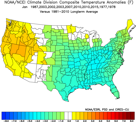
The new JMA on Thursday morning may require an update again as it has frequently given us a jump. If cold leaves, I think it will come back in January, which remains the same as last month's outlook:
.png)
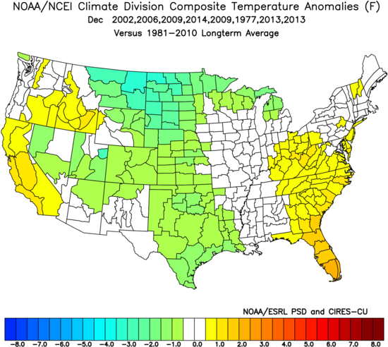
Analog:
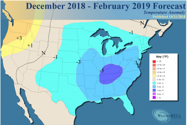
All roads lead to February, which should be the coldest month of the winter.
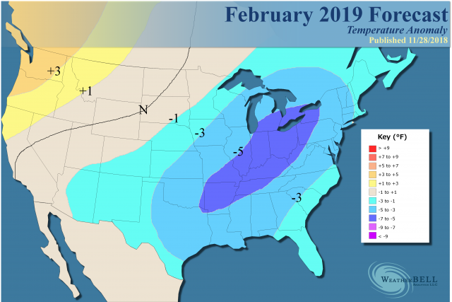
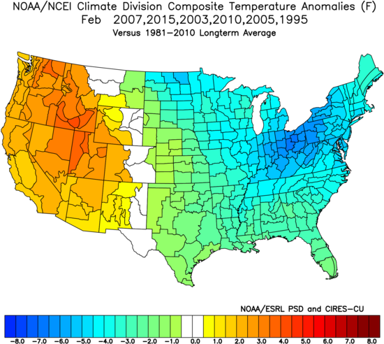
The 4 top analogs since the start of the century come up with an extremely cold February. We threw in 1995 and 2004, warmer analogs, to come up with this map:
Analog and Model Discussion
The astounding linkage to 2002 continues. The last 45 days have looked like this:
.png)
Given the upcoming 15 days of cold, this will be very close to the same period in 2002:
.gif)
This will be the coldest October 15-December 15 since 2002. Remember, 2014 was mild in October and warm for all of December. On the other hand 2002 had a warmer period before the core of winter. Look at the period December 15, 2002 to January 4, 2003:
What the Euro Weeklies showed earlier in the week was very similar to this. Then the whip came down for the rest of the period in 2003:
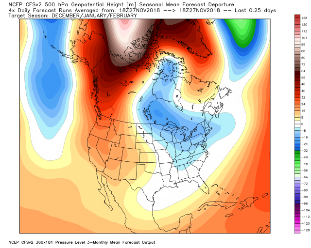
In essence, I am thinking the milder period will be an isle of mild in a sea of 60 days of cold before and after. We have alluded to the prime antilogs of 2001-02 and 2011-12, and it's hard to believe the opposite SST pattern from those warm years would produce a warm solution this year. The CFSv2 has been warm all along, but it drops bombs like this run from 06z November 27:
.png)
Then it flips back and forth from run to run:
.png)
It then went to this:
Now this:
.png)
It has a blow torch winter nothing like what we believe:
.gif)
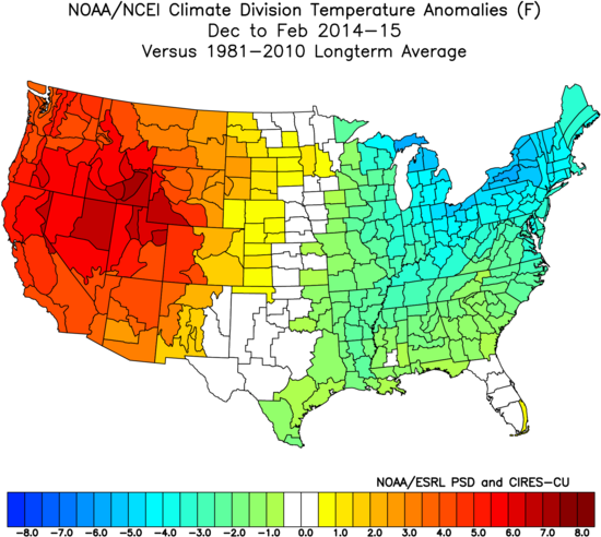
The current El Niño is most like the El Niño of 2014-15 (the Super Niño was the following year). The winter forecast that year had this:
.gif)
We wound up like this:
This is much closer the JAMSTEC, which is a model that is heavily tuned to the El Niño and Indian Ocean Dipole:
.png)
Even it was not cold enough, and this year it has this:
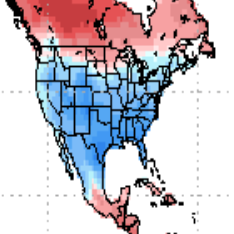
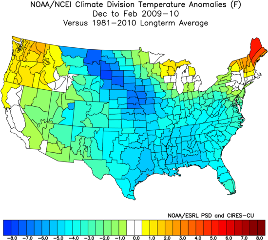
This is what this model is made for. In 2009, the previous Modoki El Niño it had this:
.png)
We wound up like this, even colder:
The point is it was giving us hints to the cold that was coming, while the U.S. CFSv2 was not. The CFSv2 has been all over the place, and one has to wonder how a model changes every 6 hours as if some kind of change actually is taking place in the large-scale drivers. Besides, even its run with a strong ridge in the area where we think a negative will develop in the means is suspect. Another run puts the trough in the Pacific but does not respond over the East, so it's also suspect.
So, we are staying the course, homing in on the front month and allowing for a warmup that occurred in another year that has looked like this so far (2002). It has also looked amazingly like the opposite of what the antilogs would give. The January-March period looks cold and perhaps severely so, centered on February.
Technical Discussion on the MJO
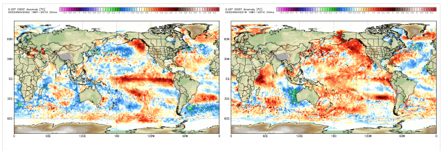
The latest CFSv2 shows the antilog/Pioneer/WeatherBell winter idea holding its own for the next 20 days. Every time I start tinkering around with other years, something happens that gets 2002 back in focus. The major similarities in the SSTs are the El Niño and what is going on over the northeastern Pacific:
The MJO disappeared in 2002, and with good reason. The very cool water and lack of gradients probably dulled the pattern enough so it would fall apart. There is no such thing going on this year. That is one of the biggest differences I can find between the western and eastern Indian Ocean. It's a warmer planet, stronger input and I would be surprised if the MJO just disappeared into the null phase for any extended period. That being said, the words of Tom Downs are certainly something to think about:
I remember this clearly from 2002-03 - during Modoki El Niños, the MJO tends to shut off or get very weak:
Anecdotally, we’ve always talked about how November-December tends to play out differently than January-March. I wonder in these weak Modoki years if this can be explained by the MJO falling off. That’s not to say the MJO won’t re-emerge later in the winter (it will in late January or February), just that we will spend much more time in the null phase in late December-January. We should see a spiraling down after this last autumn burst.
There has to be a stochastic/random element in all this, and the key is to figure out when and where the MJO shuts down. I know Joe B. has talked about the MJO extensively this fall, and I think this lines up with his thinking to some degree. I just want us to be hyper-aware.
This is not us competing with each other, but exchanging ideas. Given 2002 ruling with the sensible weather, does it continue to rule? Do the antilogs take over? If it does try to get warmer, you can see the cold coming back anyway. It isn't worth changing long-standing ideas that are working simply because modeling is throwing us for a loop. Even if the model is changing, what has happened globally so all of a sudden it's seeing something that looks opposite?
My take is to absorb any bumps but stay the course overall. Obviously, we are in extensive discussions about it internally, but this will be quite the test of ideas. I may be overreacting to a pet idea of mine - that enhanced SSTs are giving more amplitude to signaling mechanisms. I believe the modeling has a rough time handling the overall warmer globe. In the case of the MJO, warmer water would aid convective processes.
There is also a scientific paper, "Submonthly Forecasting of Winter Surface Air Temperature in North America Based on Organized Tropical Convection" by Wenqing Yao, Hai Lin and Jacques Derome:
Pages 51-60 | Received 16 Nov 2009, Accepted 11 Nov 2010, Published online: 23 Feb 2011 https://doi.org/10.1080/07055900.2011.556882
The lagged temperature composite shows an extensive intensified positive SAT anomaly over southern Canada and the northern United States 10–15 days after the occurrence of enhanced convection over the Indian Ocean and the Maritime Continent and reduced convection near the tropical central Pacific.
Bingo. Now you see why I am all about the sinking forecasted on the JMA and another modeling in those areas (an antilog to a known warm signal). So we have to watch the Indian Ocean into the western Tropical Pacific. It seems to me where water is cooler relative to areas around it, you are likely to see more sinking.
In the end, my take is that the MJO is going to stay active, though Tom's points are certainly front and center given the Euro from Monday night went to a 2002-like pattern for mid-December onward. We have been looking for some warming, and one may argue the convective burst 10-15 days ago and the time lag is what is fighting the cold.
This has been the second coldest November since 2001 and the 60 days ending December 15 will be cold, even with rotations into the warm phases at times. The ideas on the "lag" are something to factor in, but it's tough for me to believe that the opposite SSTs as what occurred in the warm winters are going to produce a widespread warm winter. With the warmed state of the Pacific, convection is begging to continue to go off, so I think we are looking at a different type of Modoki El Niño.
In addition, there is a refusal of the SOI to crash, and that has not been seen with an El Niño since 1976. It finally did crash in December that year, but the cold of November this year is comparable to that year.
Note on other models
The WeatherBell Pioneer model is steadfast in its cold winter forecast:
I have reviewed the other models in the previous posts. However, a look at the UKMET shows it's actually stronger in February:
Centered on January, it's not as amplified.
.png)
Like many other models, it resembles the Pioneer model.
The Verdict
By mid-December we will have had the coldest 60 day period since 2002. Like 2002, some backing off, of questionable degree, is in order. However, I think the large-scale ideas described since summer will still carry the day, but not without challenge. Still, given the players on the table, the January-February part of this has plenty of potential, and our forecast reflects that.