Winter 2021-22 Update 4 years ago
September 30, 2021
- We have made no changes from the August issuance regarding the overall temperature and snowfall forecasts.
- We are expecting a fast start to winter from the Plains eastward.
- There is strong analog support from models through mid-winter.
- Overall the coldest weather should be centered on the Great Lakes and into the upper Mississippi Valley.
- Please read for details on WeatherBell's proprietary research.
Winter Pattern Hypothesis
The established major warmth over central North America to start October will get undercut as the jet in the Pacific starts slamming into the Northwest. Then, it will send energy into the southern Plains. If we get the MJO into the favorable phases for the Tropics, we will see tropical interaction. All this low pressure to the south naturally forces the positives to the north. Since the northwestern Atlantic is so warm, it is more than happy to contribute to the ridging. So this will continue to work its way to the northeast, and once over northeastern Canada and Greenland, the trough can run rampant underneath. Then whether cold air can be delivered over the U.S. becomes a matter or source-regions of the air masses. The threat of early severe cold relative to averages (example November 2018 or November-December 1950), rests in how much positive there is over northwestern North America. A sudden shortening of wavelengths that develops a low in the Gulf of Alaska and it would be Katy-bar-the-door cold if we get MJO cooperation.
However, as this process continues the combination of the MJO likely advancing and feedback that occurs in the subtropics as the jet strengthens over the southeastern U.S. will start forcing the Southeast ridge to appear. Then it will become a fight between that and the cold air that can drain into the U.S. and push.
There are winters in the analog package that broke (1950, 1989, and 2005), while others had a back-and-forth pattern biased cold (1995 - remember January 1996 there was a great thaw before the cold came back). Basically, it's chaos and random, but there is the likelihood of plenty of cold air on the playing field over North America in the mid and late winter, but resistance lurks over the Southeast.
As I said you will see this section in all of the longer-range discussions. So given supply situations, it is a winter where weather may be ultra-important. Unless you get a total breakdown as we saw in the post-1989 and 2005 cold starts there will be enough demand to warrant plenty of concern. Even as 2018 fell apart, December of that year and 2017-18 found the MJO stuck in Phase 7 in February before the wild March comeback. God help us all if we ever run a winter coast to coast (November-March). The last one really was 1995-96 as they were more common before the Atlantic warmed. That 1995-96 is in the package is of concern but right now it is not the kind of stand we want to take. Interestingly enough that hurricane season had an in-close active season but the bigger long tracked storms recurved. Only Opal in October hit as a major, and again the October tropical link is what I am looking for to hone the forecast.
This is not that dissimilar to last year - and with good reason. It is based on a set of analogs that includes last year. We have also incorporated two new analogs, 2018-19 and 2013-14, due to Joe D'Aleo's research.
The analogs that provide the foundation are the winters of 2003-04, 2005-06, 2008-09, 2017-18, and 2020-21. The commonality of these include:
- Colder than average Mays preceding the period across much of the nation.
- A high amplitude MJO in the preceding spring, which carried into the hurricane season. Cold phase MJO springs usually have big U.S. impact seasons behind them, and that pattern carries into an early winter correlation.
- Summer SSTs and hurricane season activity, which signals the tendency for Greenland blocking in winter (especially early).
This also means a rough early winter in western Europe.
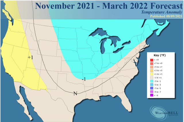
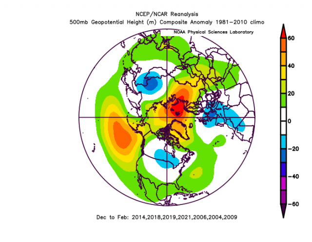
So the analog looks like this for November-March:
The heart of winter:
.png)
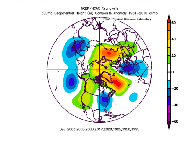
Hurricane season analog:
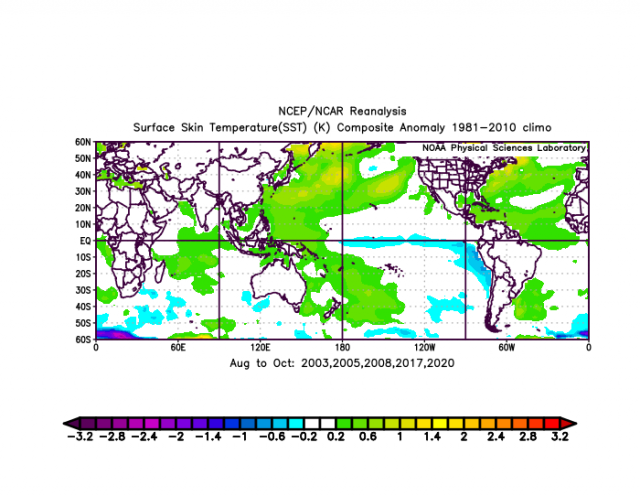
Notice the warmth in the northwestern Atlantic. In the heart of the hurricane season, that supports ridging at 500 mb over southern Canada and into the northwestern Atlantic. This usually leads to higher than average impacts on the U.S. coast. It also is a source for heat to be pumped northeastward.
Keep in mind the analog years you see were determined by the preceding Mays and the MJO tendencies that occurred in those springs. So we were formulating the forecast for the following winter starting in the spring. That has appeared on our Premium site for a few months now. This seems to be falling into place like dominoes.
Also, note La Niña. La Niñas, like El Niños cannot be broad-brushed. They produce different outcomes based on the total global picture, including how we get to where we are going. Some of the worst winters in the East, where La Niñas are commonly portrayed as warm, have been La Niña winters. The most graphic example was the big-hitting winter of 1995-96 after the big hurricane season that year.
The theory is the global pattern that produces a cold May in the U.S. and a high amplitude MJO, left to its own natural evolution, will lead to a certain type of winter, especially the front half. Then, the seasonal jet gets strong enough so it can force destructive interference; through feedbacks and stochastic events, along with the natural seasonal change, the pattern breaks in midwinter. It's why some of the winters in the analogs years you see go opposite ways - 2003-04 had one of the coldest Januarys on record in the Northeast while 2005-06 was one of the warmest ones across the nation. If we wanted to stack the deck cold, we could throw out 2005-06 and substitute 1995-96, but I feel recent winters plus the uncertainty that happens with time needs to be accounted for.
The Winter SST forecast on the Euro
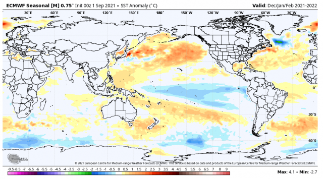
Note the warmth in the northwestern Atlantic, the cool central tropical Pacific, and the warm tongue coming off Japan into the north-central Pacific. What this tells us is the model, as of September 5, is backing up our flow chart that started this past spring.
When we go to the 500 mb analog, we get this for November-March:
.png)
By midwinter, it's breaking down the blocking and trying to pull the trough back. This is a notorious feedback error on the Euro, and while it may be right, I like our analogs through this period:
Pioneer:
We have to factor Joe D'Aleo's Pioneer model in.
What is really wild is the agreement about December. First of all ensemble models in the longer term, due to their nature, tend to only "hint" at where it might be cold, as they tend to wash it out. So what I like to do is see where it has it warm and then figure out where there is going to be a cold response. Think about this. If the global temperature is above normal (it is) then there still has to be compensating cold somewhere.
The Euro is marching in step to our ideas. The model under-forecasts low-level cold. In November and December, there is going to be an eastern trough. November:
.png)
December:
.png)
When the trough pulls back in December there are strong positives over Alaska. That is notorious for pushing cold into the nation, though resistance from the Southeast ridge will develop. Hence the fast start in the East, but then the worry about it getting warmer later. That being said, there should be a lot of cold air around.
January:
.png)
February:
.png)
March:
.png)
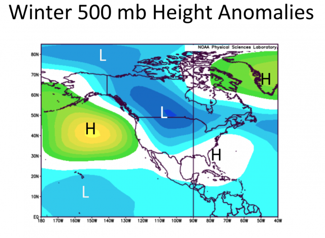
Chances are the warmer areas will be warmer. Where it's just looking neutral will be colder. The position of the warmth to the north of Alaska and near Greenland, along with the hints of a trough in the Gulf of Alaska, western Europe, East Asia, and along the East Coast all mean that all those areas may be colder than normal. What does our selected analog look like for December?
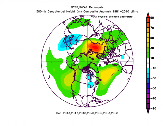
There is the trough over the East, centered on the Great Lakes.
Note that there are some other years I have not thrown in (1950, 1985, and 1995). If we use them it gets flat out severe:
Last year we saw how three weeks of cold air intrusions into Texas can change the whole picture despite an overall warm winter.
The Verdict
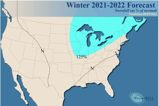
Overall it's a bullish signal for early winter. I have left out of the analog some heavy pre-21st-century big-hitting winters. If those would get into the package, it would seal the deal. There is enough variance and swing, so prepare for bursts of higher than normal wintery weather, followed by a backing off. The wintery period will outduel the milder periods for the end result being a bit snowier than normal (population-weighted) with near-normal temperatures overall.
The antics of the MJO will be huge. Each Weekly Winter update will be dealing closely with that, as it's a huge driver. Models unfortunately are horrible at forecasting it, but I hope you have noticed that since the spring of 2020 we have had skill in hitting what it's up to. The MJO has also been a big help in 1-2 month forecasting for everything from summer cooldowns to hotter periods and hurricanes. After seeing last winter and the forcing we saw, a valuable lesson was taught and what I decided to do is start constructing this winter's ideas this past spring. I am showing you some of the links here and so the lesson of last year may have given us some knowledge as to how to deal with this year. Obviously, any future event is not etched in stone. Given how bad modeling is I should probably not be happy it agrees with the flow chart analogs we are using. For now, that is a good sign, though.
In the end, we have tweaked the analogs but still have the same temperature and snowfall looks. It looks like the Euro Seasonals from September are backing us up.
Notes and Asides
There is the darkhorse disaster of 2000. There is always a bias confirmation tendency in me if I think I am on to something. I realize that and try very hard to create storylines that I want the atmosphere to move along. I am certain by now you are well aware of how we have constructed this scenario and so far, to a large extent, the storyline has moved according to plan. An added plus would be the idea that it perhaps become possible to get a jump out to 6-9 months.
There is always the chance no cold air comes. What is scarier, though, is the thought of the kind of early onslaught we saw in 2000. Tom Downs has brought up we have a similar SST configuration if one adjusts for the warming:
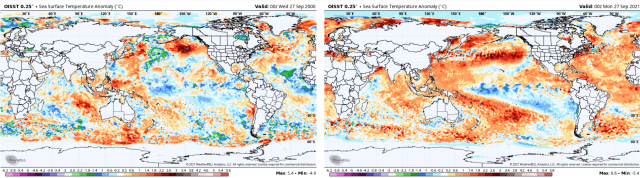
A notable difference is the Main Development Region, and perhaps that is going to lead to the impactful hurricane season end game, something we did not really have in 2000.
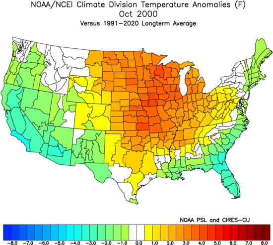
However, what we did have was an October similar to what we have forecasted now (see above):
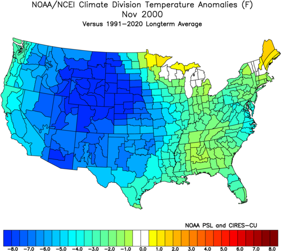
This was followed by November:
December:
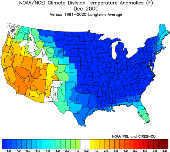
Combined November-December:
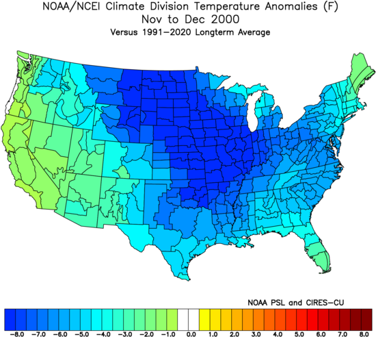
While not in the package or not being forecasted now, it does join a slew of scary analogs in the package, which given the supply and demand of today's world could be a real problem. It is something I felt needed to be outlined. Our forecast is what it is as from this vantage point it looks that way. Keep in mind in addition to this extreme other similar years lurk just behind the leaders.
So it's something we will be watching for, though not yet in any way forecasting or even adding to the package, which is colder than normal anyway.
The winter afterward was not as severe, though still colder than average versus the current 30 year means: