Winter 2017-18 Early November Outlook 8 years ago
November 7, 2017
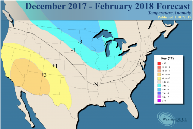
- We are shifting the core of the cold air eastward for the winter.
- High stakes forecast relies on warmer mid winter period to balance out front cold.
- MJO will play huge role.
- I am very encouraged that the modeling is moving toward our idea.
Since I am more confident about cold in the front part of the winter, the forecast has changed to this:
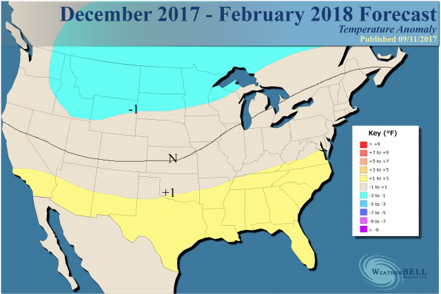
The old forecast looked like this:
The forecast we have had out stressed this winter would be a wild ride. Our analog packages, including the WeatherBELL Pioneer model, have been colder in the East. The Pioneer model was excellent in the cold winters of 2013-14 and 2014-15, but while doing a good job in the middle atmosphere over the past two winters, its low level temperature response was not good. However, this year more cold is on the table, and the pattern is going toward our analogs.
The big worry here is a very warm mid winter period, with the return of cold later on. We have low solar activity and an easterly QBO, which favor an enhanced MJO. Should it go into the warm phases like it did in 2005-06 or last winter in January, an entire winter forecast can be blown to the four winds.
The current analog package incorporates all the La Niña and active hurricane season analogs I have been writing about (and have not used since 2010). My error in 2010 was that the cold was longer and stronger - I correctly forecasted a flip to a positive AO in mid-winter, but it made little difference as winter kept coming. That idea is on the table since 2010 is a strong analog, along with 1995 and 1950 (they are double-weighted). However, so are years like 1998-99 and 1999-00, which had similar active Atlantic hurricanes and low activity in the western Pacific but also had warmer water in Nino1+2 (eastern Pacific) versus Nino3.4 (central Pacific). That La Niña was also much stronger. The weaker La Niñas tend to be colder for the U.S. if Nino1+2 is as cold or colder (and it looks that way this winter).
As a side note, it is fascinating to look at the Atlantic hurricane seasons of 1933, 1995 and 2005 independent of any other idea. All were highly active years and all had very cold Decembers. Two of them, 1933-34 and 2005-06 had blow torch Januarys followed by winter's return later. Even 1996 backed the core of the cold to the west in January, but then it came back eastward later.
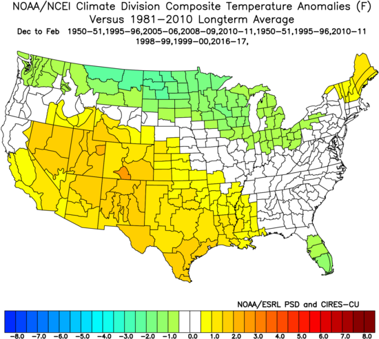
First of all the analog, which double weights my strongest years, single weights the others, and throws in last year because I want to make a point about Nino1+2 looks like this:
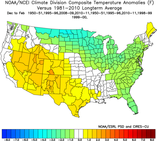
Without the years with the warm Januarys:
Basically the forecast is a compromise between the 1995-96 option, which essentially ran the table (as did 2013-14) and the worry about a strong warm phased MJO rotation, or a sudden warming in Nino1+2 (both occurred last year and were likely not mutually exclusive).
The years used had a warm October:
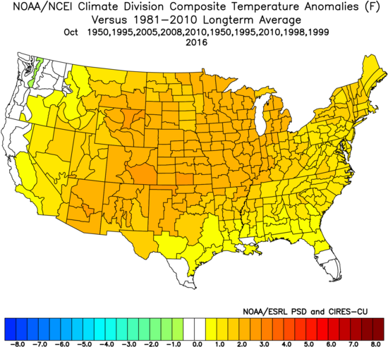
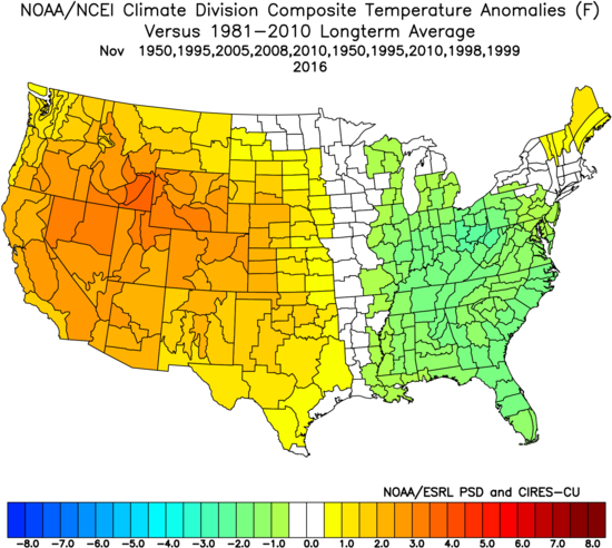
This was followed by a colder November in the East, which looks like is evolving now:
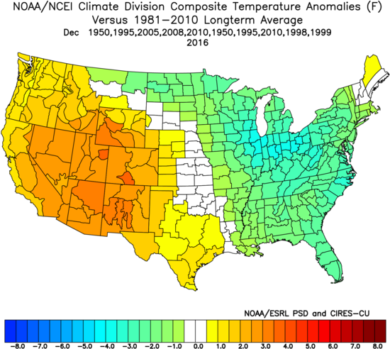
Those years had cold centered in the East in December:
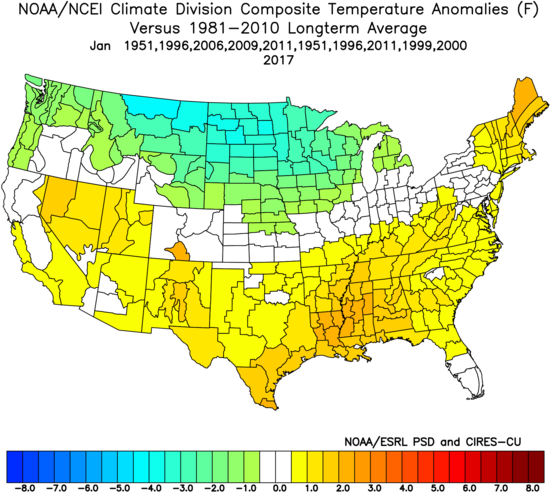
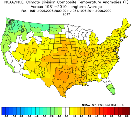
There was a pullback from January into February:
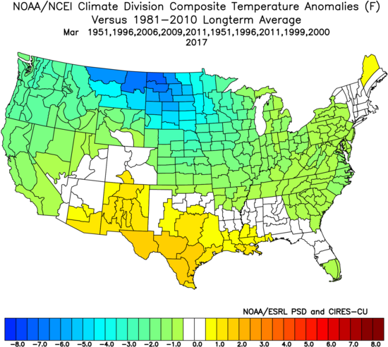
In March the cold came back:
As for snowfall, I have not changed the snowfall forecast. The pattern should feature a jet stream cutting in from the west-northwest and buckling near the eastern seaboard early. It should then pull back, perhaps with plenty of fight between warm and cold. This volatility leads to precipitation and I do think even when areas of the nation are warm, cold will still be around to fight.
.png)
In terms of the past five winters for the nation as a whole, this should be a more widespread winter. I think there will be periods of shifting, as to where the worst of winter will be. The forecast balances out two dangers: (1) that the 1995-96 example tries to run the table and (2) if the MJO is amped-up and goes into the cold phases, it could get really ugly given there will be an opportunity to put snow down.
The other winters are when major warmups beat back the overall cold. My strategy from the get-go is to let you know this is not some ho-hum winter. A lot of forecasts issued after our first one back in summer seem to echo what we have been saying. That being said, I had my suspicions on the modeling having to shift eastward for the early winter, so I am jumping on that. I fear the threat of a mid-winter warm up. The analogs I showed you had the warm October, the cold trying to get into the East early, but also have a pull back. So the result is more cold farther to the east because of the early cold and then try to home in as we see some of the other things I just talked about. This winter has a lot of potential and certainly the way we get to the end is likely to be a heck of ride.
Note: I have been showing SSTs on videos and in past discussions, so I just wanted to be more results oriented here. The forecast is a blend of all these ideas you have been seeing.