Winter 2016-17 Retrospective 9 years ago
March 1, 2017
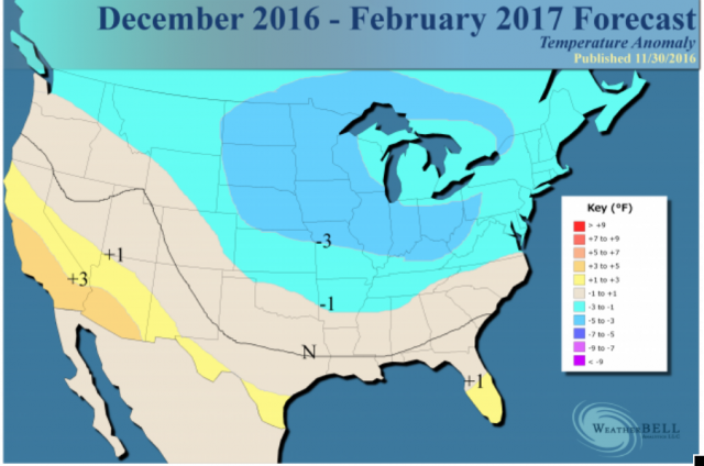
While the snowfall season is not over yet (first flake to last flake), the temperature forecast for meteorological winter can be verified.
It is a far cry from our forecast:
Note that in terms of snowfall, even in the horrible winter of 2011-12 the last major snow in western Pennsylvania was in late April.
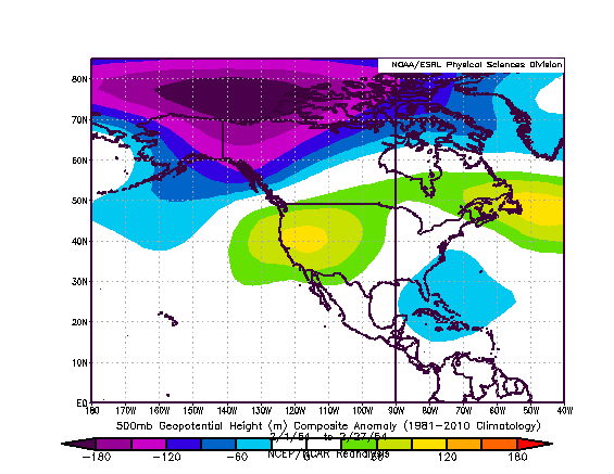
A look at the 90-day mean at 500 mb reveals the problem:
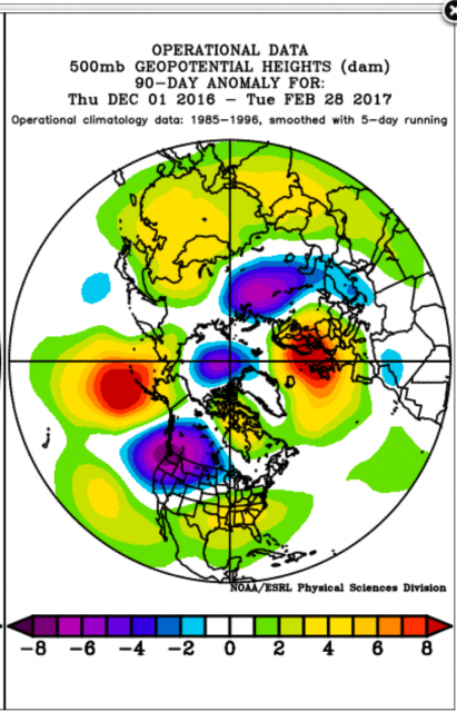
The strong trough over southwestern Canada was supposed to be weaker, with the response being a stronger trough over the Great Lakes and Northeast. We relied heavily on the European SST forecast and its winter idea, which fit my conception back in October and November for how the SSTs would be. At In October and then for January-March, I thought we were in great shape at 500 mb through January 10. The Euro's December-February idea from November 8 was good, but it was getting blown out of the water in December.
Let me explain. I can't show the Euro seasonal forecasts off their site, but the main idea of the winter forecast was that the cold would shift eastward in the latter part of the season. There were fights over the East in December, but here is how December wound up in spite of the last 10 days of warmth:
At this point, I thought we were ahead of the game. Given the Euro's 500 mb forecast from December 8 for January-March, with blocking over Greenland and a ridge just off the West Coast, I thought we were fine even then. I knew that the westerly QBO and low solar argue for a western trough through mid winter, but I thought when the cold came back in the front 10 days of January the winter up until then was cold, doing better than it was supposed to. Remember, we also caught that warm up for the end of December and we were all over the January thaw because of the wild SOI in early January.
So the January thaw came and I had no problem with that because I thought after that winter would lock and load up again for February and March. In fact, the low solar and westerly QBO tends to favor the cold shifting eastward late. The analogs for the cold northeastern Pacific pool in 2013 and 1960 were both in line with that. Since February 1954 was not on my mind (double whammy since in January I didn't even think to look there), it was not even considered. It was February that blew it up.
What I am doing here is reconstructing what goes on when I look at all this. The biases toward holding with the original idea are obvious, but what is stubbornness and what is skill is where lines can be drawn. You have seen me stick with ideas too long, but I simply do not want to be like all the rest, changing with every run and then claim one was right. There are events and seasons where it has worked well, but there is something here that happened that I will never forget. Usually when I am wrong I can always see what can go wrong, but in this case I thought I had this because we were in very good shape before the January thaw and I looked at the thaw as halftime. The 500 mb pattern for 20 days from January 23 - February 11 went pretty much toward what we thought would occur, but the response at the surface and in snowfall was muted compared to other similar patterns. There were differences of course, nothing is ever the same. So in the end a more favorable period aloft was squandered.
When I look at the SST monthly evolution, it's more clear now. In the 1954 example of record warmth, the SSTs in the ENSO regions were favorable for U.S. cold. It came, gangbusters, in March. The northeastern Pacific and the area to the west of Australia were both cold like this year and the water was warm in the Gulf of Mexico and along the East Coast. Most people know that I think foe early is friend later. That is assuming the cold is taking over in the central part of the nation. However, the configuration in the Pacific was such that the EPO would turn positive when cold appeared in the mid and late winter. In the early winter that EPO holding on to a negative value (or neutral) when cold was around allowed cold to come eastward.
In the great winter of 2013-14, warming at the end of December ruined eastern cold. Keep in mind the weekend before Christmas, widespread snow occurred, and though not of the magnitude of 2009, the wipeout of snowcover this year was earlier. The day after Christmas 2009 a lot of people had deep snow covers destroyed, too. My point is that sometimes things occur that cannot be figured out. Suppose the cold period this year was December 5-25 and the snow the weekend before was Christmas weekend. Perceptions change even though the overall reality does not. So here I am okay with the fact that it warmed for 10 days. However, I thought cold would wait, and it did not. It came roaring back to open January.
We knew the thaw was coming on January 3, when the SOI spike started. Beyond the thaw, the spike was followed by a drop, and this usually means the cold will come. The big stratospheric warming occurred and cooled Canada, but the cleaning out of cold had been so great (the stratospheric cooling was something we were jumping on for the thaw) that by the time cold air was ready to come again, the MJO went into the warm phases and thwarted it.
Here is the big point - if there is too much transience in winter, cold cannot hit and hold. I thought there would be more blocking. Why can't it hit and hold? Well quite frankly we are closer the equator than the North Pole and fast moving low pressures through the North will pull warm air up. The Gulf of Mexico is the source of how warm those warm pushed can get. The feedback of the cold pool in the northeastern Pacific with the warmth under it, intensified the trough to the northeast of the cold pool in southwestern Canada.
If the EPO goes positive, you simply have a faster stream under what blocking there is. The ridges to the southeast of the trough are stronger and more extensive, and if there is limited cold air to fight with all that warm water, the storminess and feedback for mid and late season snowstorms is not there.
There were two cases in the East where we had it, the one on January 6-7 where we held onto the westward correction because the water worked. The other was February 9-10, and of course I have no complaints about February 7-14 in New England, during that Phase 8 period. It was a great week there for winter weather lovers.
In the West, we suspected something was up because of Tom Downs being bullish on snow in the Northwest. We thought the jet would come in at least a bit, and the correction to the stronger trough was the reason behind the incredible season they had. This is well within the realms of what the weather does, but on a grander scale it shows the foolishness of dire forecasts for "permadroughts". The positive thing about the breaking of the California "permadrought," besides the swing back by nature and the longer term benefit despite some of the other things going on in the shorter term, is that it distracts from the bust that was the Texas "permadrought" that also broke last year! The situation in the West leads to the the lack of activity in the Plains and the East. The mean flow off the Pacific is not an arctic regime.
Again, why did this happen? The evolution of the SSTs speaks volumes. In fact, the very bathtub slosh theory I touted as to why December would get cold actually worked against me, since the cold did not come over the top but it came in from the west. The change in the SST pattern pulled cold into the trough as the ridge oscillated more between Siberia and Alaska than over Greenland. So when you look at the 500 mb pattern, the problem is one of feedback in that what happened to create the trough over southwestern Canada also cut what was supposed to happen farther to the east. The less the trough there, the more farther east or vice versa.
So let's look at the November SSTs:
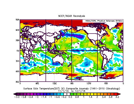
This is okay with me, given what I thought. December turned colder than normal in much of the country:
.png)
December SSTs to set up January:
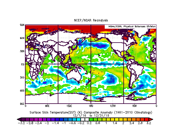
By the end of December, Chicago was way ahead on snowfall, and below normal on temperatures. The East was a week removed from snow around Christmas and the West was getting pounded. The ENSO areas look like a draw. Here is when we decided to stay the course, and the big cold comes to start January.
January temperatures wound up like this:
.png)
I did not mind this because of the reversal I thought was coming after the big thaw.
January SSTs that set up February:
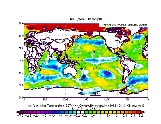
Here is when I was expecting an American Pie February, perhaps for a while in the Northeast and Northwest, but it turned out to be a pie in my face.
.png)
500 mb:
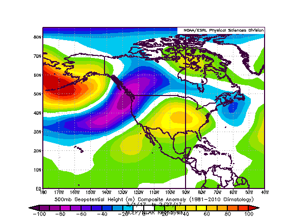
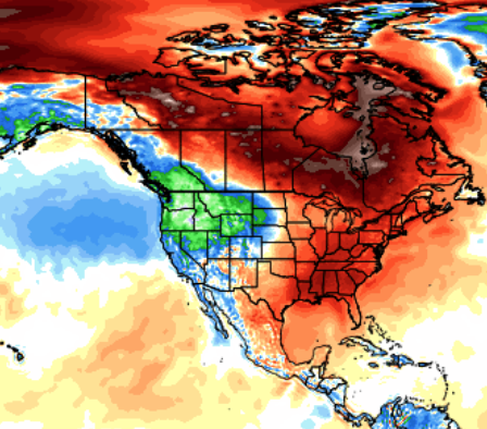
This appears to be second only to 1954:
.png)
Remember, in the first 10-15 days of February winter tried to come on. At the end of January, I had no beef at 500 mb with what had occurred until then. I saw that Nino1+2 was warming and the Gulf and western Atlantic were very warm. This still does not say February will be like 1954.
February SSTs turned out like this:
.gif)
The Nino1+2 region warmed dramatically during the month. The Gulf of Mexico and western Atlantic remained very warm. The cold pool, there in 1954, but also in 2013 and 1960 is there, but unlike this year, no El Niño was coming on and the water was cold to the west of Australia (like 1954). In addition the fact that, overall, it's 0.2°C to 0.3°C warmer than it was, has to have some effect that is hard to quantify. I thought it would lead to more blocking (and there was), but it was a bit far to the west and it fed the mean trough over the Pacific Northwest.
In essence, I am reminded of Godfather 3 with Michael Corleone sayinging (though a bit different), "Just when I thought I was out, they pull me back in!"
This winter, it was just when it looked like the cold was coming, it pulled back again. So in a nutshell there it is. Hopefully next winter I will be better connected and make all of you a forecast you can't refuse, rather than one you do not want to remember.
For me I will never forget the winter of 2016-17. If you do, you will repeat the same mistakes.