Updated Winter Forecast 4 days ago
October 29, 2026
- Analogs incorporate very strong El Niños with strong El Niños that had a negative PDO.
- Early in the Winter Season, the strong stratospheric warming event and hurricane-impact analogs suggest December should be cooler than the strong Niño analogs.
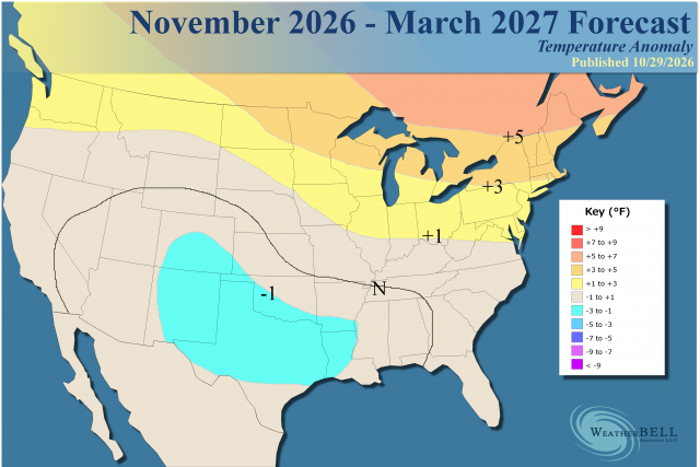
- The overall temperature forecast blends analogs and is very close to the model blend.
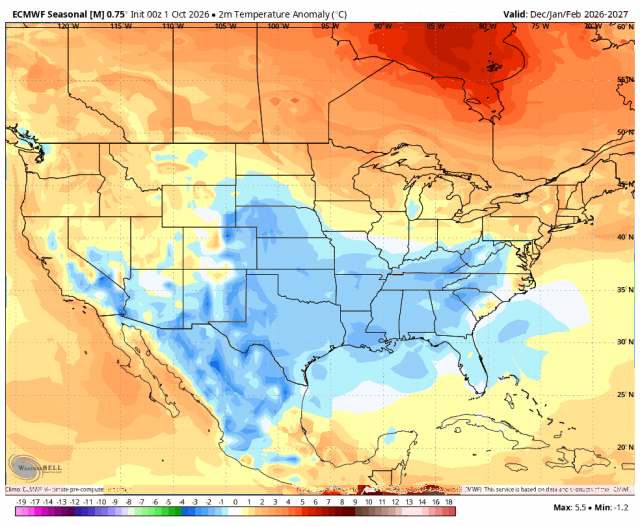
- The expected pattern favors cold, wet weather to the south of I-40, with increasing warmth and dryness farther to the north.
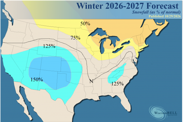
- Heavy precipitation is likely in the West, southern Plains, and along the East Coast.
- An extension of heavier precipitation into the Mississippi Valley is due to some of these El Niños having storm tracks quite far to the north.
- The snowfall forecast for the Plains has been increased, along with the southern and central Appalachians.
- A second stratospheric warming event is being hinted at for mid and late winter.
Analog:
What we have this year looks like the earliest peak of a strong El Niño. If the bias-corrected forecast is right, this would leave it short of the record, which is back-to-back +2.4 in the heart of the winter of 1982-83.
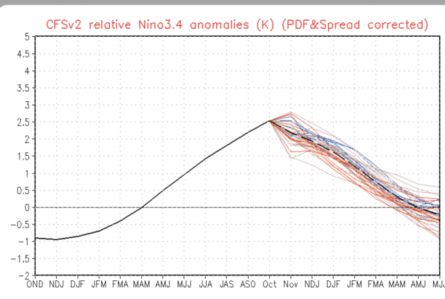
There are three possible paths through this winter. The first one has about a 50 percent chance (meaning the other two are less), and that would be that it is colder than what we have forecasted. This would be accomplished by the end of November into December being much colder, rather than just a bit colder as we have. That would already put the forecast behind. Then the mid and latter part of the winter, even if we are right, would mean the entire period can be colder.
The second idea is that the latter part of the winter season turns out as cold as the CFSv2 is forecasting. The hurricane analog I use to mitigate the front part of the season does not apply to the latter part. The idea of a second stratospheric warming event, when it would make even a bigger difference, would support that. The position of the positive in the North, in relation to the negatives from the Pacific into the U.S., is crucial. The farther to the north with the positive and the trough goes farther to the east rather than hovering in the Southwest, as is the normal strong El Niño analog. So it can turn colder. I think this is a 35% chance of happening.
The third possibility is that it is just as flat-out warm as much of the broad-brushed El Niño ideas say. So basically I have an 85% confidence that it's at least as cold as we have it.
The other factors from the first winter discussion remain, but these new factors (a strong stratospheric warming and the tropical impact idea) have entered and are extra ingredients.
Analog Discussion
The choice of analogs for the winter rests upon being at least a strong El Niño in the Relative Niño Index and blending that with the Negative PDOs that have occurred.
The last time we had something like this was during the winter of 2023-24. That winter had (what has become) a normally warm December, but then a major arctic outbreak showed up in January. However, as it arrived, the MJO responded to the rapid, anomalous warming around Australia and shifted into strong warm phases, so the winter never returned to what it could have been.
I expect it to warm around Australia again, but the El Niño, because it is so much stronger, will still be able to be warmer than the water around Australia. So it won't have the impact, unless some kind of tomahawk gets thrown in the form of underwater input.
In previous strong El Niño winters, 2015-16 had three weeks of winter with a major blizzard in the East in January. The classic 1997-98 was a warm, wet winter for most. It actually had a very low amount of economic impact from weather. Interestingly enough, November and December started cold. As mentioned, December has usually been warm in recent years, as you will see below.
1991-1992 produced a short-lived cold period but overall was a warm winter. 1982-83 had one major blizzard in February within a short-lived period of a cold and stormy pattern in the East. In the South, it was a cold, stormy winter centered in Texas.
1972-73 was almost snowless in the East, but was a big winter across the South. 1958 and 1966 both wound up colder than normal for January-March and had some legendary storms.
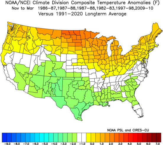
So there is quite a variance in these types of winters, but usually the northern part of the nation has the warmest weather (relative to normal). The analogs show that.
The bottom line is the colder part of the winter is expected to be later. However, December is liable to be quite a bit colder than the major strong El Niño winters. So I don't have much change here.
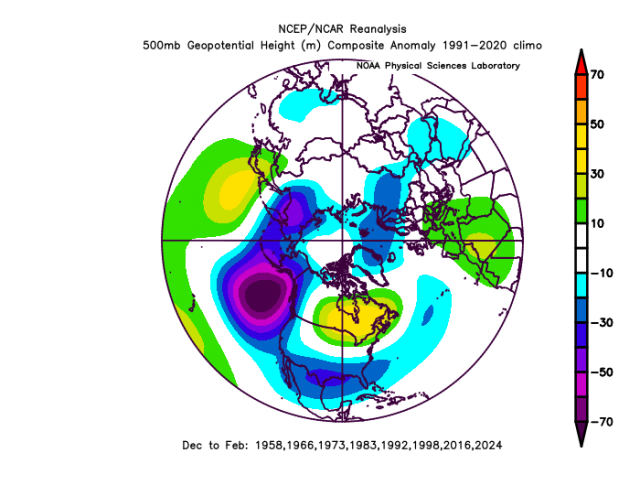
So the 500 mb analog for this winter (which includes all analogs):
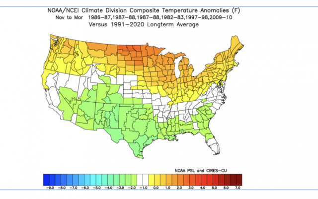
November through March temperatures:
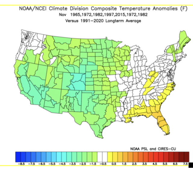
November temperatures:
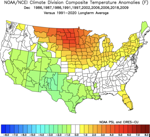
December has the strongest tendency to be warm. These are the strong El Niño analogs:
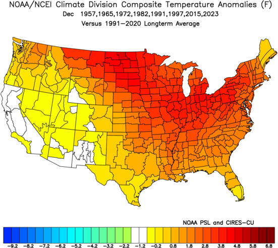
You can see our analog is a heck of a lot colder than that:
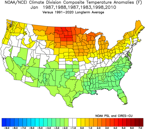
January:
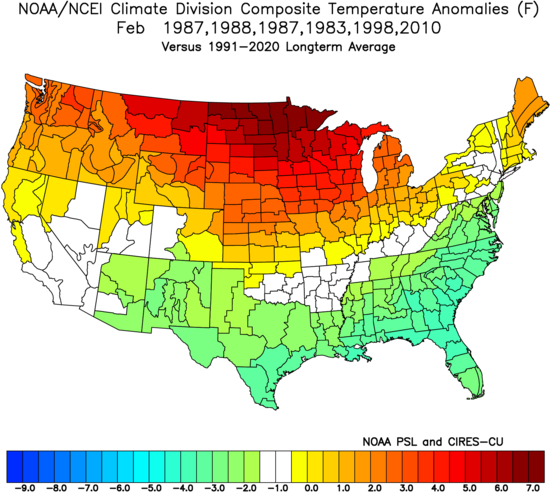
February (this looks too warm, but it's where we are now):
March:
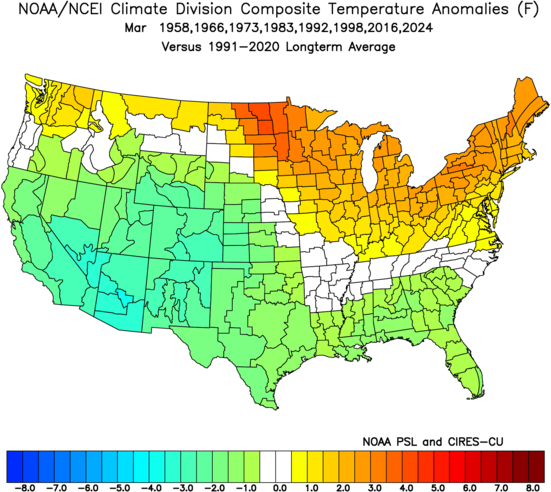
So if December and February are colder, then of course the entire period will be colder. This is a concern.
Model Discussion
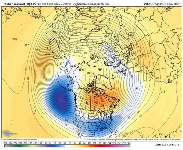
The 500 mb pattern for December-February from the Euro Seasonal:
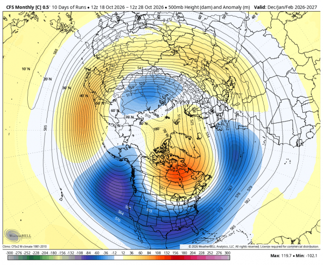
CFSv2:
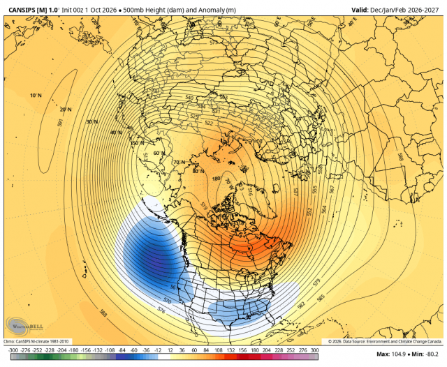
Canadian:
Here is the blend of the three:
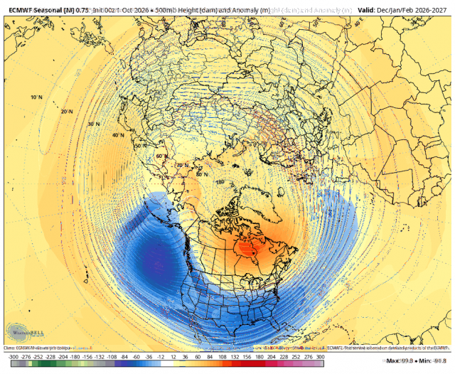
The big key is the latitude of the positive and the longitude of the US negative. There is a westerly QBO, which argues for a more southerly position. Look at the average of the warmest versions of strong El Niños: 2015-2016, 1997-1998, 1991-1992, 1982-1983, and 1972-1972.
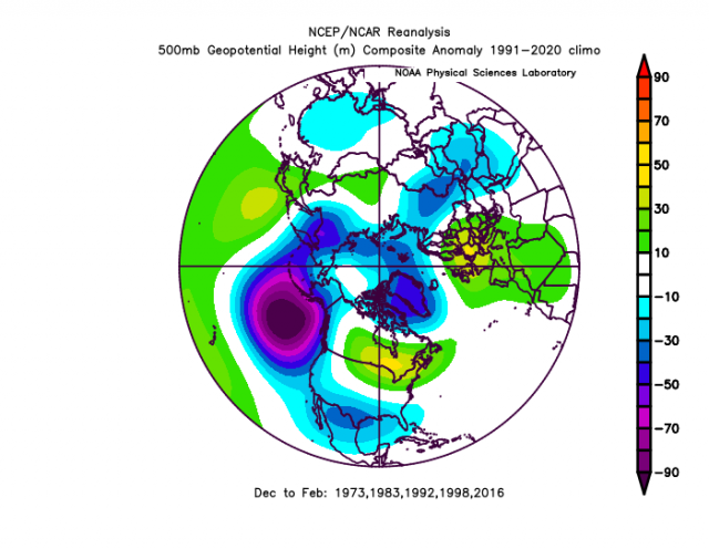
So the model blend is different. The positive is farther to the south, and the negative is back to the southwest.
JMA:
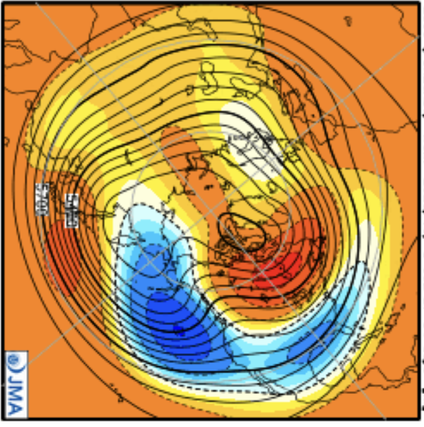
So you can see ours is a bit different and a compromise.
The Canadian, Euro, and CFSv2 blend for December-February:
The blend for precipitation:
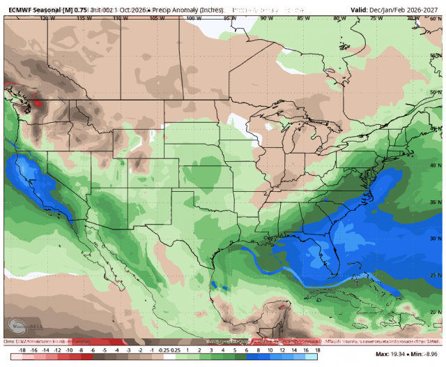
This will end the drought in the Southwest and raise the threat of major snowstorms. As you see in our snowfall forecast, we are centering the biggest snowfall anomalies in the southern Rockies, in the south-central part of the nation. I have expanded snowfall in the central Plains compared to the first issuance. The biggest uncertainty is the East Coast. It will be close enough to the storm track and heavy precipitation, and temperatures will likely tilt colder if there is more snow upstream. Instead of one big storm and a lot of rain, you can get 2, 3, or 4 storms in a row, as we saw in 1966, 1987, and 2010. So the forecast shows higher bust potential in the Northeast. The mountains should be above normal.
The Verdict
We should buckle up and prepare for a winter that is not one-size-fits-all. This winter has a lot of potential. I think the forecast is at least as cold as it will be. When you blend all these things together, you try to weigh the factors. So these forecasts add all these factors, but the final result may be one of the least likely final answers, and I think we will have to watch for it to be colder.
Up front, we are already seeing quite a difference from the average strong El Niño. I have been bringing up factors that made this El Niño unique, like the negative PDO, the unprecedented early stratospheric warming event, and the hurricane impact analog. The latter two matter up front, when winter is usually warmest during an El Niño.