Bastardi- SOI Crashing Against the Nina, Models Taking MJO Where Lovers of Winter Want It 13 years ago
I was awakened by screams of horror in the middle of the night... as I could hear the anguish from the multitude as the European operational came in and flattened everything. The model has not been the same, at least over the US in its operational runs, since they made changes 2 years ago. While it is still better than the GFS, it's not because it has elevated its level.
This pattern is loaded with potential, as the MJO on all the ensembles now comes into Phase 8 and is heading for phase 1. This is going to happen because there is a major disruption in the SOI as the dailies have been well below the La Nina base state for a week now and are the strongest negatives we have seen in over a year seasonally adjusted. The La Nina is starting to die and that should open the pattern up for fun and games for the US.
Here are the latest ensemble forecasts, from the US, ECMWF, UKMET and JMA. Of course I am partial to the JMA since summer when it beat me silly on the heat wave.
.gif)
ECMWF
.gif)
Canadian
.gif)
JMA (only to 10 days)
.gif)
The first issue is the model getting rid of the system coming out of the Southwest Tuesday. While competition between it and the short wave coming in behind it may flatten it, this still looks like it will run snows from Texas to the Northeast in the Tuesday PM-Thursday morning period.
The HUGE ITEM THOUGH IS THE THREAT OF THE MAJOR STORM AND SEVERE COLD SHOT SUNDAY-TUESDAY
The storm that reaches the west coast Tuesday heads for Mexico. The kind of deepening occurring the middle of next week near 140 west in the Pacific should show 4-7 days later over the eastern US. It now appears the option of staying WEST of Mexico is off the table, so we are left with this key to turning much of the south and east into a winter wonderland either staying over Mexico and leaving us holding the bag ( Euro/and to some extent the GFS) or the kind of phasing that could make what has happened so far this winter worth your while, just for a system like this. I have this Saturday in the Gulf and Monday near Nantucket right now, but if we see the kind of trough depth that you see here at 150 west Wednesday we should get one heck of a trough in the East by next weekend, and the system over Mexico should at least feed east into it. There are ducks on the pond here.
The winter so far makes me gun shy, but given the flip in the SOI, the powerful cold over Europe, everything is there for this pattern to go haywire over the US. The first attempt is this weekend, it backs away a bit, but is ready to refire after that and into March. The last time we saw this kind of cold in Europe in the mid 80s, it was precursor to the Reagan outbreak and then the wild trough late in Jan 1986. Notice the pattern over the Northern Hemisphere Jan 24, 1986 00z
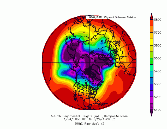
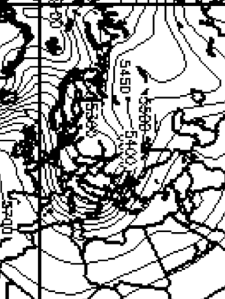
Close up of Europe shows how that trough dug in
Now look at the US a couple of days later.. sub 510 cut off over Tennessee! Brutal cold, but instead of one big storm, a lot of smaller waves
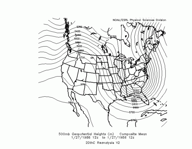
and yes, this was the arctic attack that may have set up the Challenger disaster.
But I showed you 85 (snow in Rome) and now you see 86. So if you wonder why I am thinking this pattern is going to go the way I portray, more or less, it's that everything is falling into place.. the strat warm, Euro cold, MJO, nina breaking down. And when that has happened before, it has gone from mild to wild in the US and the cold got bold and took hold.
And the GFS ensemble is seeing what should happen with time in this pattern, that is why it keeps seeing the trough. The fact is that only N America has not been touched by the world wide cold wave, At the very least, you are seeing why patterns like this before have produced the kind of weather I think is on the way .
thanks for reading, ciao for now