Bastardi- Winter! 13 years ago
December 1 11:30 AM
For the record, this is the 3rd issuance of a winter outlook, the first one being Sept 9, the bigger one the 28th. I don't flip-flop around as much as what may be expected, and instead wait till the final issuance to update if I think the pattern is in line overall, (example, cold for December, though admittedly it's turning out aimed further west than originally thought) and then trying to adjust the back months.
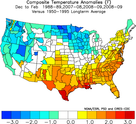
The main theme is the same. The winter is NOT as cold as last year and the year before, and probably not next year or the year after. There are changes to the forecast as I have incorporated a new set of La Nina analogs that match up to the three closest global sea surface temperatures using the common denominators of a weak to neutral AMO, a cold PDO with a La Nina, and a weakly warm Indian ocean dipole. Three years stick out now: 1988-1989, 2007-2008 and 2008-2009, with the last one being double weighted as it's the closest. Since the new forecast will be a blend of the new analogs with the old forecast, the old forecast analogs are still in there. However, we have to factor in the greatest physical matches to the forecast now. Obviously those old analogs did their job.. the cold came strongly to open the first 2 weeks of the winter season in December and though it's aimed further west than I originally thought, it is very much for real.
Other analog years in the 1950s found the Pacific colder, the Indian Ocean much colder and the Atlantic warmer. Last year had a warmer Atlantic and more pronounced La Nina. I am convinced, though, that we have to place the La Nina in the context of the physical realities around it, and the set up this year is more like the years talked about above.
The ENSO 3.4 is indeed weaker than the model had earlier and is closer to our idea: weaker than last year and certainly no super Nina.
.gif)
The water temperatures for the 30 days ending November 26 look like this:
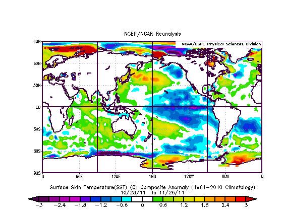
We have a warm indian Ocean and the Atlantic is warmer in the mid latitudes than the tropics, with a tongue of warm water in the central Pacific.
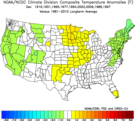
Again, the common denominators: La Nina, cold PDO, weak positive AMO, Indian Ocean neutral to warm
Closest years:
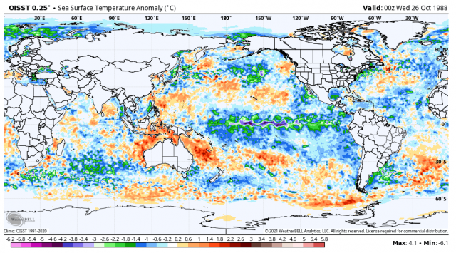
1988:
2007:

2008:

each one of these has parts of them which are not ideal. But, blended together, we come up with this, which is not bad:
The maps below showed the original forecast and the updated one that came out last week as I slashed and burned the southern plains, probably not enough and warmed the northeast a bit. it's based on the cold start in the South and the turn to colder later in the month across the North as the analog of the pattern kicks in. It is already showing up on some of the runs. I am throwing out the CFS because it has been erratic and is getting off to a horrible start (it has only gotten cold in its weeklies recently). The idea is cold develops over western and central Canada mid and late month. The warming in the South chops away at the cold. The cooling in the North does the same at the warmth. The forecast on the top has morphed into what you see further east.
(1)(1).jpg)
Interestingly enough, the analogs give us this:
The latest weekly CFSv2 temps look like this
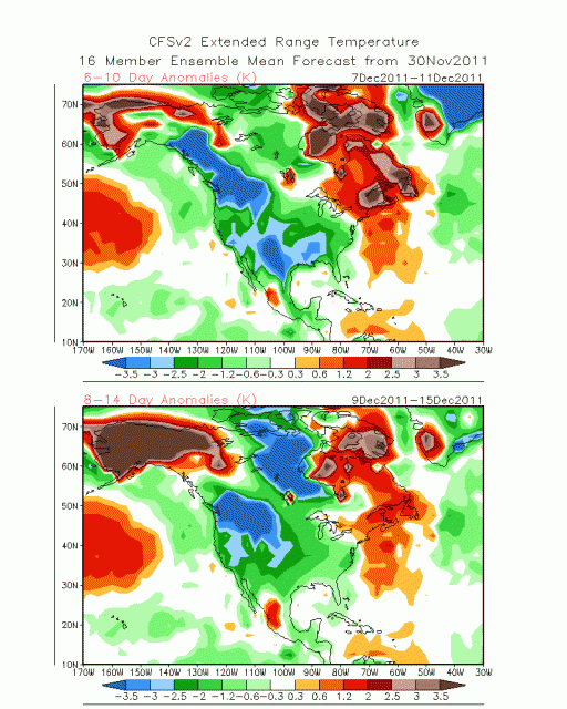
This busted horribly in Canada from a couple of weeks ago
Look what it has for the periods we are in the next week

We need to look for southeast and southern US warming to develop, though the further west one goes, the less the chance it warms.
For January we have a CFS that looks like this:

Our old forecast like this:
.png)
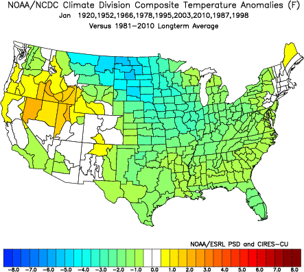
The analog looks like this:
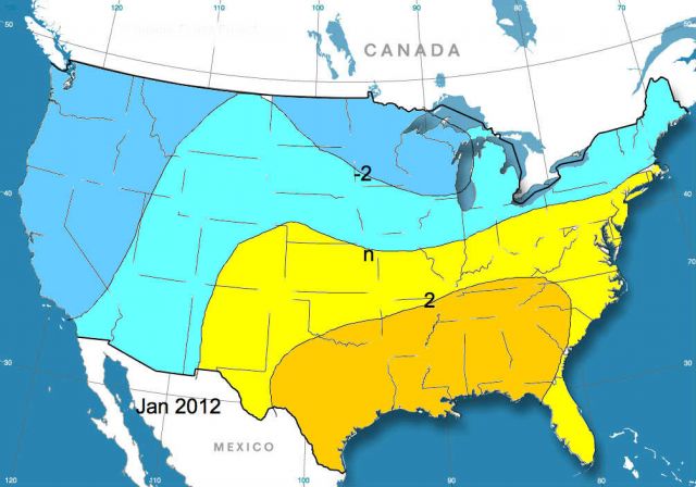
New forecast looks like this:
For February, the CFS is very warm, opposite the analogs.
CFS:

Analogs:

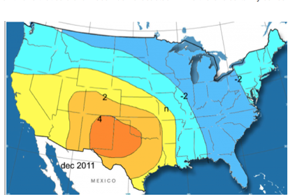
Old February forecast, which given the model so far west with the warmth the analog so far east, I am keeping about the same.
.png)
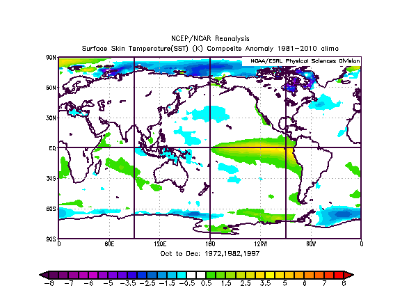
The winter analog overall looks like this for temperature:
Precipitation:
.png)
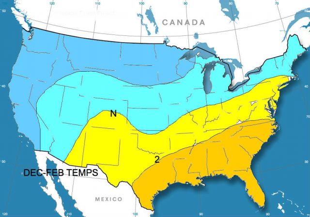
Amazingly given the reversal I am seeing, that temperature map for the analog would be very close to what the blend would look like for our forecast below:
Snow
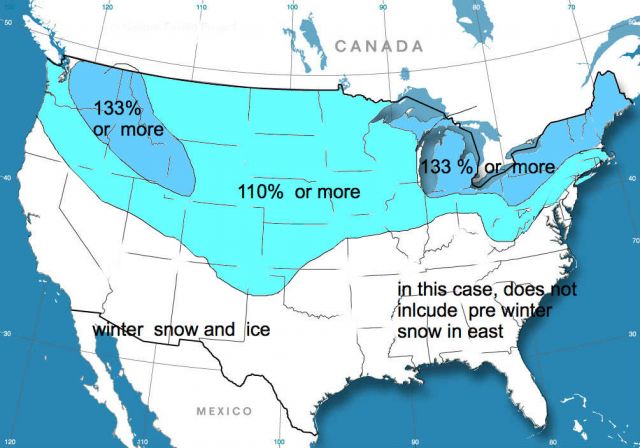
With precip the way it is, the snow/ice in relation to normal still looks pretty good with areas near and north of the normal line from the Rockies east seeing above normal snow and ice, and the Pacific Northwest having a snowy winter. The temperatures are approximations of the monthly ideas with some rounding for a more uniform map. The story is cold in the West and across the North, warmer over the Southeast, and a big fight in between. The temperatures you see will be a product of big swings, and while this is not as cold as last winter, this is no walk on the beach.
I think there are less noreasters than last year with a lot of storms trying to cut to the lakes, but secondary-ing. The statistics in the I-95 corridor are simply to hard to argue against as far as early snow and warm oct/nov back to back, yet the wetness argues for more. I have pulled the above normal line (going forward) back northwest here. This is a battle ground winter, but not as bad snow wise as last year, and the way we get our temps is with plenty of variance this year.
January is a bear.. A warm one, would mean a greater threat of mid and late Feb into March cold. A cold one means it warms for Feb, but look for winter to come back March and April and the return will be something that will cause another late growing season in the north. The tornado season should be much less active than last year, but still above normal
Summer..more toward 2009 and that implies cooler than last summer, earlier also. I will opine on that a bit later