Bastardi-Florida Battered By Heavy Rain, Strong Winds 13 years ago
Below are multiple Premium blog posts by Joe Bastardi regarding the system that hit Florida over the weekend of October 9, 2011.
October 9 12:09 PM
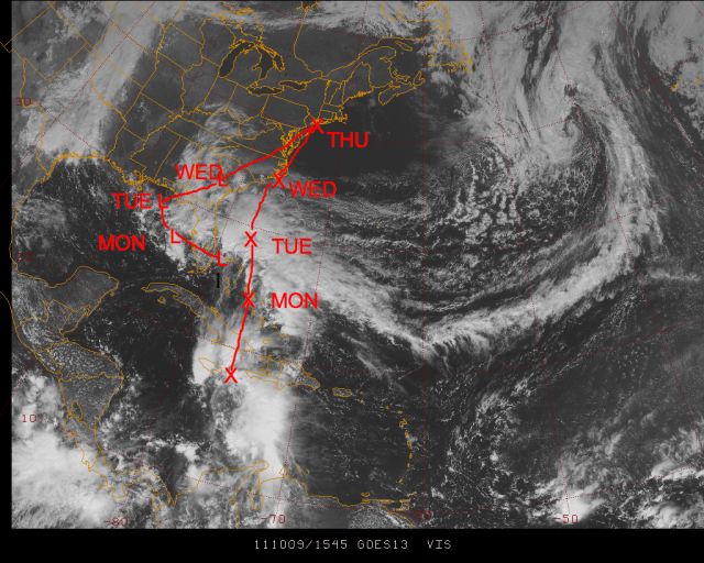
A ragged low level center has formed just wnw of Grand Bahama and can be see on the sat pic here
.gif)
This has little wind, or light northwest winds southwest of its center, but the convection to the north has sustained gales with gusts over 50 mph in it. The data buoy just off the Fla coast has had wind gusts to 50 mph and seas to 21 feet already
.png)
The radar pic should reveal increased organization as this comes for the coast and the obs will be very interesting where the center crosses the coast and northward this evening.. It would appear the space coast is where the core of the nastiest weather will occur. This system will reach the northeast gulf tomorrow and mill around south of the Florida Panhandle for a couple of days

The situation is extremely complex and that is why we probably wont get a name out of this since there is going to be a second system pinwheeling northward east of the original system. One can look at the cloud shot and see that already below
The x marks the track of what should get pulled up out of the Caribbean and the L is the current system. I expect winds to die down with these features for a time Tuesday as they compete, but gales may resume Wed into Thursday near and east of the eastern center as it consolidates again. There is also a chance that the primary system that will cross Florida tonight does get enough of an independent look to it in the northern gulf that it will get classified. As it is, tropical storm conditions will occur on the Florida east coast with it ( one can argue they already are as 21 foot seas are not chicken feed) This is one of these events that is falling between the cracks as far as classification goes, as it has its origin over tropical waters but certainly does not have all the needed pure tropical aspects to it.
thanks for reading, ciao for now
October 9 04:11 PM
Another un-named storm joins the Jersey Devil of 2009 and the late Sep 2008 storm... I am baffled at how things like this can not have a name, but cloud swirls in the middle of nowhere can
Granted its not Andrew, but it is causing tropical storm conditions and does appear to have enough structure to warrant a name
http://radar.weather.gov/ridge/radar.php?rid=MLB&product=N0R&overlay=11101111&loop=yes
Here is the still at 5:15 pm

winds now gusting over 50 kts just off fla coast
cmon guys you cant let this go by now.
.png)
Now there is no excuse winds are gusting to near 65 mpbh pressures are falling rapidly as the center of what should be named is coming very close to the data buoy 20 miles east of Cape Canaveral. You dont see that from non warm core systems over the gulf stream in hurricane season. Remember it is one month beyond the center of the season, so its like seeing this on Aug 10th as far as the season goes.
Look at the obs
 |
Wind Direction (WDIR): | NNE ( 20 deg true ) |
|
|
Wind Speed (WSPD): | 40.8 kts |
|
|
Wind Gust (GST): | 54.4 kts |
|
|
Wave Height (WVHT): | 22.0 ft |
|
|
Dominant Wave Period (DPD): | 11 sec |
|
|
Average Period (APD): | 8.0 sec |
|
|
Atmospheric Pressure (PRES): | 29.63 in |
|
|
Pressure Tendency (PTDY): | -0.16 in ( Falling Rapidly ) |
|
|
Air Temperature (ATMP): | 76.6 °F |
|
|
Water Temperature (WTMP): | 81.7 °F |
|
|
Dew Point (DEWP): | 72.9 °F |
|
|
Combined plot of Wind Speed, Gust, and Air Pressure | |
Now the data plot
.png)
Its oct 10 in tropical waters.
I am not counting irene as anything more than 1 hit, even though its being counted as 3 landfalls. This is certainly worthy though of being counted as a impact storm. I think any rationale observer of the weather, and certainly people on the space coast, will agree.
Non tropical systems do not produce this kind of weather in the middle of hurricane season on the central coast of Florida
Its hard to fathom how in 2011 a storm with winds gusting to almost hurricane force can hit Florida from the sse and not be named.
Look at this pressure/wind graphic from the data buoy east of Cape Canaveral, and they did not even get into the center!
.png)
The pressure reached 29.52, but the wind has swung into the ene after gusting to near 70 mph out of the nne. The waves reached 22 feet BUT THE WAVE HEIGHT INDICATOR HAS FAILED at 8 pm. Its nonsense to think that a pressure fall from 29.78 to 29.52, a fall of close to 9 mb in about 3 hours, is not a tight warm core system. That is a trace from a tropical cyclone! Both temp and dewpoint have come up 5 degrees in the past 5 hours!!! How is that not tropical with a water temp of 81.7.
This has to be counted as an impact storm, a solid tropical storm, there is no question.
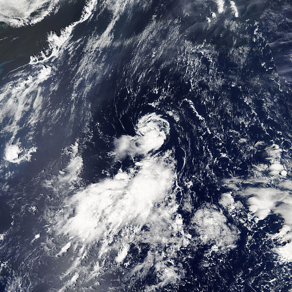
Look at the tightness of the wind on the doppler in the banded structure of a tropical cyclone

The cloud shot shows the rounded CDO though displaced northwest, breaking away from the north south band to the east

While pressures are falling in the northeast gulf, there is a chance this hugs the east coast of Florida and tries to stay offshore and reaches the Ga coast, or the carolinas, Tuesday still as in tact system. How long it can be non classified by TPC is their call, but it is an example of why I get into these rants, Look at all the verifiable evidence in front of you folks, and then look at this, a storm like tropical storm Jose
and again you see why my cry for years in the wilderness... closed rotary circulation, verifiable gales in at least one quadrant, origin over waters greater than 25C, name it. should be the standard. What is baffling is that the closer in, the more impact it has, the less chance it has to get named. Its as if its meant to cause confusion, though I really cant believe that is the case.
What a night!
October 10 06:34 AM
I am posting this from a subscriber who was sending down obs. I further updated this on the video this morning. This is going to get an impact rating of a tropical storm, making the 4th impact storm of the season, 3 of them tropical storms ( only Irene gets an impact as a hurricane and is only credited for 1 landfall, not 3):
A few more local obs...81 mph from a Air Force tower at 60 feet. 10/09/2011 1020 PM 2 miles SSE of playalinda b, Brevard County. Non-thunderstorm wind gust m81.00 mph, reported by other federal. USAF 60 ft wind tower number 393 measured a 70 kt/81 mph wind gust. 10/09/2011 1020 PM 3 miles se of playalinda beyalinda b, Brevard County. Non-thunderstorm wind gust m78.00 mph, reported by other federal. USAF 60 ft wind tower number 394 measured a 68 kt/78 mph wind gust. 10/09/2011 1030 PM 3 miles E of Haulover canal, Brevard County. Non-thunderstorm wind gust m75 mph, reported by other federal. USAF 54 ft wind tower number 19 measured a wind gust of 65 kt/75 mph. 10/09/2011 0945 PM 3 miles SSE of playalinda b, Brevard County. Non-thunderstorm wind gust m69.00 mph, reported by other federal. USAF 54 ft wind tower number 394 measured a 60 kt/69 mph wind gust.
This joins the Rosh Hoshanah storm of 2005, the un-named 991 mb storm in late Sept 2008 at Myrtle Beach , the Jersey Devil of Sept 2009 as some noteworthy examples of the maddening, and for no reason in my opinion if they simply adopt a standard I have been advocating for year.. closed rotary circulation with VERIFIABLE gales in one quadrant over water 25c or higher.. name it, systems that cause disruption and damage to US interests that dont get named, while naming nonsense in the middle of nowhere.
There is no justification for this. Can you imagine what the guys in the Melbourne NWS office had to go through. getting hit by clearly a system that had warm core characteristics, yet not being able to say so because of the controlling authority did not respond. And you wonder why I have some of the views I do on bigger items
I'll tell you how fired up I am . If there are cases where an insurance policy was for a tropical system, and as much as I understand and sympathize with the the major pressures that industry is under I would be glad to get on the stand and testify for the idea this should have been a named storm. One has to stand for truth, and this is most certainly an example of that! In fact, since this is a relatively minor event compared to lets say a major hurricane ( funny this had heavier rains than Jeanne in 2004 that hit that area) a company could look awfully good by not challenging the idea this was a warm core system, if you can see how that would spread good will about a company. Interesting idea.
ciao for now