D'Aleo- EC(s)...Foehn home 14 years ago
January 7, 2012
La Ninas usualy have a jet stream farther north in the United States. The cold tend to be in Canada and in the far north, warmth in the south of the jet in the mean. As we showed, there are often periods during La Nina winters when Pacific air dominate even in the north. We have certainly seen that this early winter.
.jpg)
This usually is in winters or periods when the AO is positive (left below).
.jpg)
This zonal flow means downslope flow from the north south mounatin barriers.
Warm and dry winds descending mountain slopes are found around the world. Since they were first studied in the Alps, they are generically known by their local Alpine name: the Fohn winds (or Foehn, or more correctly Föhn winds). Fohn winds flow off mountain ridges, usually in the lee of the prevailing wind direction. In Libya, their local name is ghibli, while in Java they're called the koembang. From off the Andes, they blow as the puelche, or on the Argentinian pampas as thezonda. In North America, they have had several local names including the Santa Ana winds of California, but most of us know them as the chinook of the western Prairies and Plains regions.
The western mountain and the Chinook wind (foehn) that warms the already mild Pacific air. In generally downslope winds produce warming due to compression. In the Chinook, the is also warming due to latent heat release each time the air climbs the mountaians and rproduces clouds and snow. This reduces the cooling from lifting. When the air comes donw the other side, it is immediately warms as a much faster rate.
A strong Chinook can make snow one foot deep almost vanish in one day. The snow partly melts and partly evaporates in the dry wind. Chinook winds have been observed to raise winter temperature, often from below −4 °F to as high as high 68 °F in a very short period. One of the greatest recorded temperature change in 24 hours was caused by Chinook winds on January 15, 1972, in Loma, Montana; the temperature rose from -54 to 48 °F).
When relatively mild and very moist Pacific winds make landfall, they encounter the coastal mountain ranges of British Columbia and the Olympic and Cascade mounatins of the Pacific Northwest As the flowing air mass rises toward the summit ridges, it cools until it eventually reaches its saturation temperature. At this time, its water vapour burden condenses into liquid water, first forming clouds, then precipitation. Much of that liquid, or frozen, water will eventually fall as prodigious amounts of rain or snow on the Coastal Ranges, watering the lush temperature rainforests for which the region is famous.
Although the airmass cools by expansion as it rises over the mountains, it gains back a great deal of heat when its water vapour converts to liquid water — the latent heat of condensation which amounts to about 2.5 kilojoules or 597 calories per gram of water. (Additional heat — the latent heat of fusion — is released should the liquid water freeze to ice within the airmass.) By the time the airmass has traversed all of western North America ranges, most of its water content has been lost through precipitation; however, a good portion of that released latent heat still remains in the airmass.
When the airflow descends from the high ridges of the last mountain barrier, the Rockies into the plains, it warms through the compression of the air, like the air in a bicycle pump when the plunger is pushed down. The airmass warms by about 9.8 Celsius degrees per 1000 metres of descent (5.4 Fahrenheit degrees per 1000 feet).
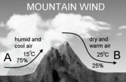
Since many of the ridge lines in the Rockies are 3000 metres (10,000 feet) above sea-level and the Alberta plain is around 300-1000 metres (900-3300 ft), the air will warm by 20 to 30 Celsius degrees (36 to 48 Fahrenheit degrees) in its descent. The air parcel is also very dry since it lost most of its initial moisture content crossing the mountains while gaining very little new moisture during its journey. This warm descending air is the chinook.
The most impressive chinook winds blowing off the Rockies can reach speeds of between 65 and 95 km/h (40-60 mph) with gusts exceeding 160 km/h (100 mph). When blowing at those speeds, the chinook can tip railcars off the tracks and blow semi-trailer units off the road.
Impressive as the chinook is as a wind, the temperature changes it brings can be astonishing, often as much as 36-45 F degrees in an hour. The greatest chinook temperature jump ever recorded occurred on January 22, 1943, when a chinook shot the temperature in Spearfish, South Dakota, from a chilling minus 4oF at 7:30 AM to 47oF just two minutes later! And, in Pincher Creek, Alberta, a chinook jacked the temperature 37.8 F degrees in four minutes on January 6, 1966.
No wonder, the chinook has the reputation its name "Snow Eater" engenders. The deadly-to-snow combination of high temperature and dry air rushing by at high speeds can literally remove a foot (30 cm) of snow in a few hours. And it may not just melt the snow but evaporate it as well, often all in one single process called sublimation, without leaving a liquid pool behind. The very dry air soaks up the liquid like a sponge, replenishing some of the water vapour lost in the mountain traverses.
When, on February 25, 1986, a chinook descended on Lethbridge, Alberta with winds gusting to 166 km/h (104 mph), it fully removed a snow pack of 107 cm (42 inches) in depth in eight hours. Lethbridge was left with substantial wind damage and new lakes standing in the surrounding fields and pastures.
The recent pattern has see a very cold Alaska trough and [acific flow that came down from the western mounatins into the northern plains and the Canadian Prairies. You can see the removal of the snow in the norhern areas by the zonal flow that has prevailed. The lack of snow has elevated temperatures further by 10-20F. The Pacific air alone is warm, the foehn affect adds to it, the lack of snow even more.
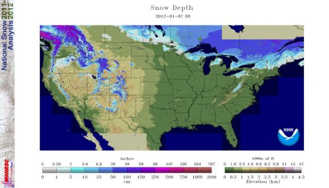
In the Northern Plains temperatures in January after one below normal day on the first have averaged 13F above normal with highs reaching 70 at Rapid City and 74 in Phillp. Records were broken set in January 1981, 1987, 1998, 2002, and 2003 in the region..
With the change in the pattern coming due to the SSW and the flip of the AO, arctic even Siberian air will invade the lower 48. This raises the prospect of a few spots in the northern plains of seeing a 100F range of temperatures in January.
.jpg)
Ironically the southern plains has been south of the jet and with a split flow with cut offs descending into the soutrhwest, New Mexico has seen snow and will again the next few days.
.gif)
This is the region last year with the suprressed jet and deep snowpack in the north where the downsloping occurred adn began the southern plains drought.
The change in the pattern will take place around the 12trh. I recall how frustrating the wait was in 2004 and 2005 and 2007 for the pattern changes we saw coming long in advance to finally take place. 5 days is a long time watching green to brown grass in January in New Hampshire,
When the cold fills the bowl in Canada and spills into the lower 48 states, the winds will flow upslope in the plains with snow finally. The boundary should see waves that will produce overrunning snows (and ice). the models suggest the Siberian connection and a major outbreak with that upslope flow. Here is the Environment Canada (EC) Global GEM 240 hour.
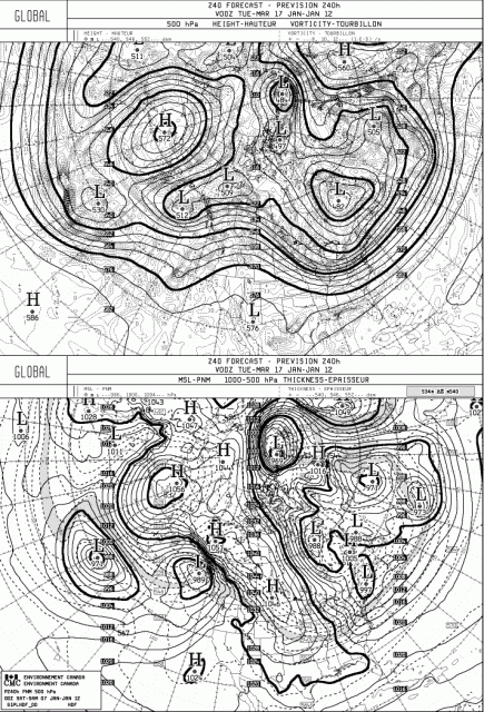
Here is the European Center (EC) 240hour from last night.

Today's EC has another freeze for Florida next weekend.
We can soon start talking specifics about events and not futures . As I said this week...PATIENCE NEEDED.