Indian Monsoon Update 10 years ago
August 11, 2015
Indian Monsoon Update
- El Niños, especially those with warmth extending into the central Pacific, tend to be associated with failed or erratic monsoons in India.
- This El Niño, though strong to the east, extends to beyond the dateline, too.
- The monsoon arrived late in southern India, rapidly moved to the north in June but faded from parts of central and southern India in July and early August.
- Though heat made the news with the late monsoon, it has cooled starting in mid-June.
- It has been warmer than normal in the drier areas.
- Cotton in the central belt from Maharashtra southward to Karnataka experienced dry conditions.
- It was wetter in Gujarat and northern Andhra Pradesh.
- It has been wetter in northern India Sugar areas (western parts of second-ranked Uttar Pradesh) and to the southeast (Andhra Pradesh) but it has been drier in top-ranked Maharashtra and third ranked Karnataka and eastern Uttar Pradesh.
- For soybeans, rainfall has been plentiful in Madhya Pradesh but short in Maharashtra.
- Little change in the pattern is expected for the rest of August through October, though the far southern sugar areas (Tamil Nadu and Kerala) may see some improved rains in September as the northeast monsoon ensues.
Summer Annual Monsoon Rainfall since 1871
The monsoon has been erratic with a clustering of lean years from 1899 to 1920 and from the mid-1960s to the mid-1980s. Last year ended up short of normal, though it fell far short of 2009's drought.
.png)
El Niño
El Niño has matured into a strong event, extending from South America to west of the International Dateline:
.png)
Monsoon Rainfall and Temperature Anomalies
The 60 day rainfall anomalies indicate a sharp discontinuity, with dryness from Maharashtra and Madhya Pradesh southward. It was wetter than normal in north-central, northern (Uttar Pradesh) and northeastern India.

As is usually the case, the wetter areas were cooler than normal and the drier areas have been warmer.

In both the drier and wetter areas, the precipitation has been erratic, typical of El Niño disruption.
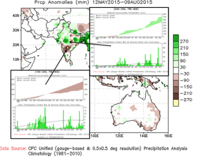
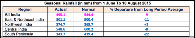
For India as a whole, precipitation has averaged 9% below normal with southern areas seeing 22% deficits.
Note also the erratic nature of the daily rainfall patterns in southern and central areas.

.png)
Cotton
In the central Cotton Belt from Maharashtra southward to Karnataka, dry conditions have occurred. It was wetter in Gujarat and northern Andhra Pradesh.

Sugar
It has been wetter in the northern sugar areas (western parts of second-ranked Uttar Pradesh) and to the southeast (Andhra Pradesh). It has been drier in top-ranked Maharashtra, in third-ranked Karnataka and in eastern Uttar Pradesh.

Soybeans
The soybean areas of Madhya Pradesh (top province) have received adequate rainfall but Maharashtra (second in importance) has been too dry.

Current and Forecasted Precipitation
Thunderstorms were seen in central india on Monday.
.jpg)
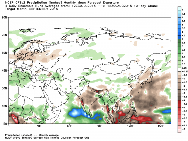
The next 10 days will see more of the same. The last 10 days of the month will be driest to the south and wettest to the southeast and in the far west (west of the Ghats).
Dryness is projected for September and October. The exception will be a burst of rain occurring to the northeast in Tamil Nadu and Kerala as the change in the monsoon during September takes hold.

Summary
Though there was a strong burst of rain in central India in mid-June, the monsoon has been predictably erratic. Deficits, especially in central and southern India have been common. The dryness will impact production of cotton, sugar and soybeans.