December 2014 Prelim Forecast 11 years ago
November 4, 2014
- December should feature a large area of colder than normal temperatures
- Potential for even colder than we have
- Examples of years where winter backed off then came back lurk
- The SST analog shows progressively colder weather for winter
- Implies room for December being less cold (but still below normal) than January & February
- The threat of a 1976 and 1977 blend lurk
Our forecast that went out last week looks good for now.
.gif)
The global SST pattern is very similar to the blend of 1976 and 1977. To make a long story short, those two analogs have a striking similarity to the SSTs this year (read below). There were differences between the two, as the November-December couplet in 1976 got cold and stayed cold, while in 1977 there was enough back and forth for a less cold look.
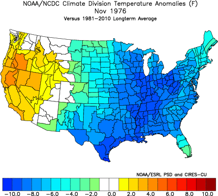
Obviously, November 1976 is much more like November 2014:
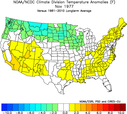
November 1977:
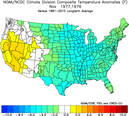
The blend of the 2 may be the best:
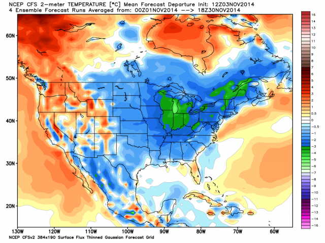
The latest CFSv2 for November 2014:
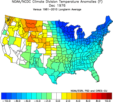
Let's look at December of 1976.
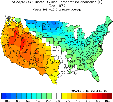
1977:
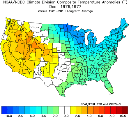
The blend:
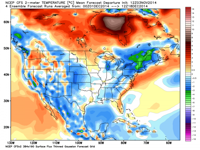
The current CFSv2 December chunk:
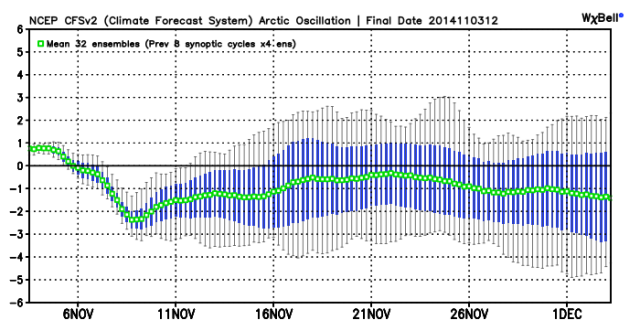
The analogs, this idea presented here and the model idea of a strong negative AO well into December all are coming together.
AO:
There is some strategy here. We are seeing the worst of our fears for November coming true. We had a large scale cool, not cold month, but it was meant to put you one up on the winter that we think will be cold, yet had much sentiment for warmth (it still does in some circles) up front.
If we look at some of the other years we have in our package where November was cold, the years when it backed away in December it wound up coming back gangbusters later. The missive below has the blocked-up look we are forecasting, but also has its most impressive cold later. The moral of the story is to stay a step ahead of what has been another winter where there is sentiment of warmth, and understand we may have to swing colder.
Comment on Dickson/Nemias Winters of 1976-77 & 1977-78
Joe D'Aleo shared a paper by Robert Dickson and Jerome Nemias, the latter being a household name to many meteorologists back in the 1970s. They showed what happened in the winters of 1976-77 and 1977-78. Amazingly the current setup now looks like a blend of both.
The key, according to these authors, was really not the ENSO, though the ENSO most likely interacted with the pattern in a way so that the physical forcing meant it could not get strong (same as this year). The big keys, in their opinion, were the tongue of cold water that worked its way eastward from off Japan and the warm water off the southwestern coast of the U.S. and even off the Northeast coast.
Look at Nemias's SST reconstruction of 1976-77
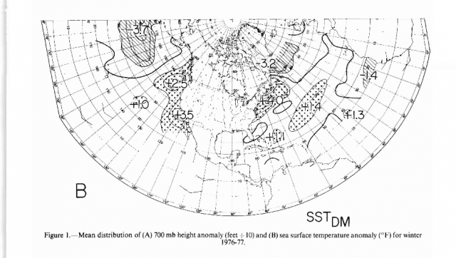
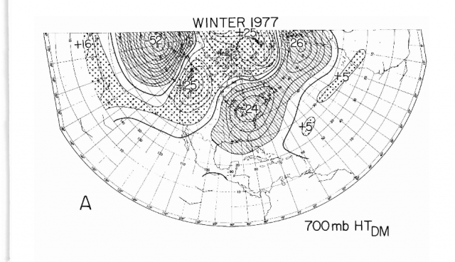
There is the warm water off the West Coast and right off the East Coast. The 700 mb pattern:
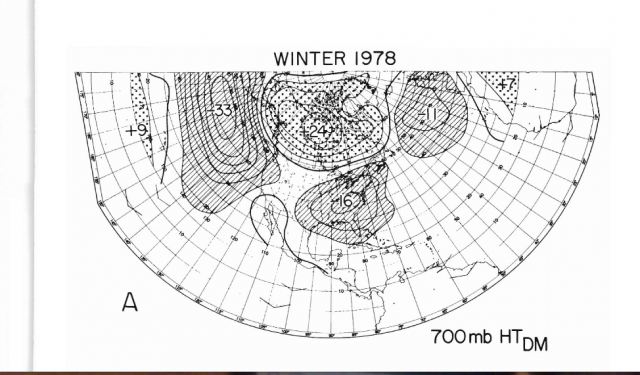
Now 1977-1978 SSTs:
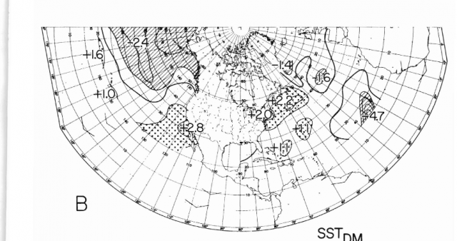
The cold water is more extensive farther north but the coldest water remains weak to the south.
The resultant 700 mb field:
Why would this happen? The cold water is a source of lower than normal 1000-500 mb thicknesses. The warmer water farther north means storms can blow up in the Gulf of Alaska and then can pump the ridges to the north and east of them (hence the blocky look). The warmth of the ENSO 3.4 supplies energy from the south for storms going by to the north. When ENSO 1+2 is warmer, that process is farther east and so there is more of a tendency for a stronger ridge farther east and south over North America in response. In any case, the blend of the two winters look like this:
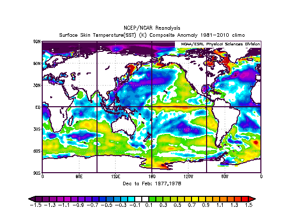
The SST forecast looks like this:
.gif)
The CFSv2 response in temperatures over the U.S. looks nothing like what the SST should give, hence we do not believe it.
Last year, when Joe D. went back to the 1917-18 winter and with 1993-94, we jumped. Make no mistake, we have a rough winter forecasted, one that will cause, if we are correct, as much or more hardship as last year. If it goes to the extreme, then once again looking back at the past, we will have added valuable insight into the final answer.