August Hurricane Impact Update 2 years ago
August 7, 2023
- This hurricane season, a September to remember is on the table.
- The expected impacts to the U.S. Coast have increased compared to last forecast.
- Keep in mind that this is in essence a "normal" season.
- 1985 and 1954 were "normal" seasons but had a high impact and this may be like that.
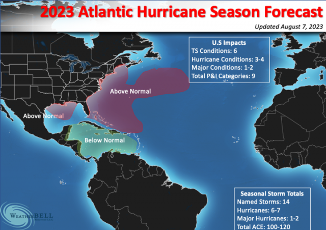
U.S. Expected impacts
Tropical storm conditions: 6
Hurricane conditions: 3-4
Major hurricane conditions: 1-2
Total P&I Category points (U.S. Coast): 9
The Power and Impact scale rates the storm intensity during the highest impact (they do not have to make "landfall", just cause the conditions). That has been increased to 9 from 8 (see Power and Impact scale). In cases like Ian, there are two different impact numbers that were added together - 4 for Florida and 1.75 for the Carolinas. The ultimate impact is Donna in 1960 (4 in Florida, 3 in the Carolinas, and 2 in New England) for a total of 9. A whole season was wrapped into one storm. Note that Canada is not included in this forecast.
These numbers have been upped slightly. I am saying 6 tropical storm impacts because I believe that when the season is done, the feature that was un-named on Memorial Day weekend off the Southeast Coast that caused a wipe out the holiday weekend in the Carolinas, hurricane-force winds to a Carnival Cruise Ship, and storm force winds on the coast, will get classified. You can't classify that January system and then let that one go. We do realize this is somewhat of a numbers game and is totally subjective.
So far NHC has classified five storms. The two African waves set off much hype as they were so early on, but they fell apart. Since Cindy, nothing has developed out of Africa. That is how it is normally until August. What is interesting is that the pattern is doing it with record-warm water comparable to the busiest of seasons. This further buttresses my argument about how the distortion of the warming can bring down activity if you boil it down to the old Texas A & M rule: Hurricanes are ways to redistribute heat out of the Tropics. If it's already being done in horizontally and vertically (i.e. warm all over) what's the need for them?
So with 5 storms already classified and 16 ACE points, we are ahead of that. One of the storms, Don, became a hurricane. Because it was around so long, it had 7 of the 16 ACE points. The January system had 1.4 ACE points. Don did not originate in the Tropics (nor did the January system or what became Arlene). Essentially the African wave season has produced only 7 of the 16 points. If we were only at 7, we would be below normal for the date.
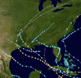
The big fear here is a spray gun season that all comes in a few weeks. 2008 was classic with 7 named impact storms in a row, and then none:
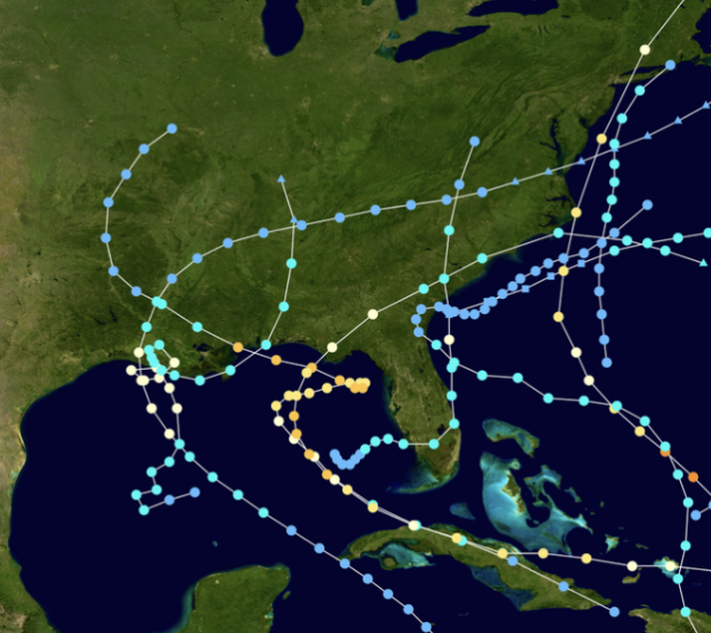
1985:
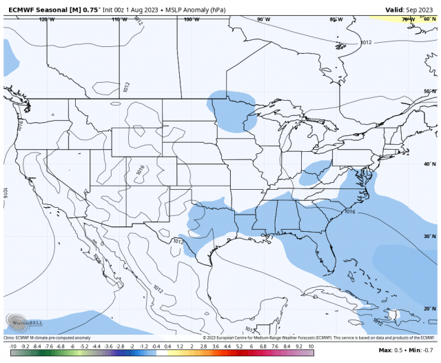
Herein lies the problem. The congregation of tracks may wind up in a similar fashion and the September Sea Level Pressure forecast by the Euro is alluding to that in the same manner its precipitation forecast from mid-September to November last year hinted at the late season activity well before the storms that hit were named.
Globally the western Pacific is doing what were saying it was going to do. The El Niño, of course. is raging full scale and is heading to what we said from early in the season:
.png)
This is in line with the preseason analogs which were way, way under our totals. However, the warm Atlantic and the Multivariate Enso index are other factors. The MEI is not responding like the ONI because it incorporates atmospheric aspects, so it means that there is a big disconnect between the observed El Niño (SST-wise) and other similar years, likely due to the distortion of the entire global pattern brought about by distorted warming. So we can't just rely on those analogs. We did not in the preseason, and the MEI gives us reason to believe that while El Niño will limit this season's potential, it will not chop it down as much as the other strong ones did.
The old PSU rule was the real hurricane season starts August 15 and ends Oct 15. 75% of the ace is in that time span, and so it may be this year. I have made changes to the impact areas where we believe a higher-than-average ACE will occur.
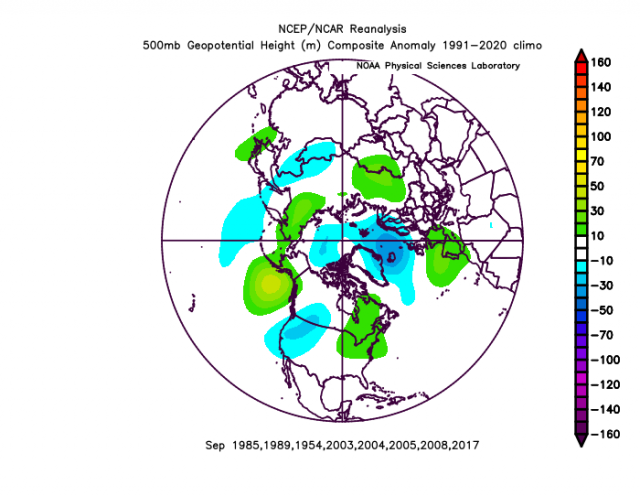
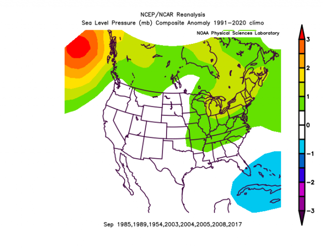
The September ECMWF forecast looks a lot like the Septembers of 1954, 1985, 1989, 2003, 2004, 2005, 2008 & 2017 with the western trough and ridging up through eastern Canada. Scaling prevents the kind of definition that is seen in the actual analog:
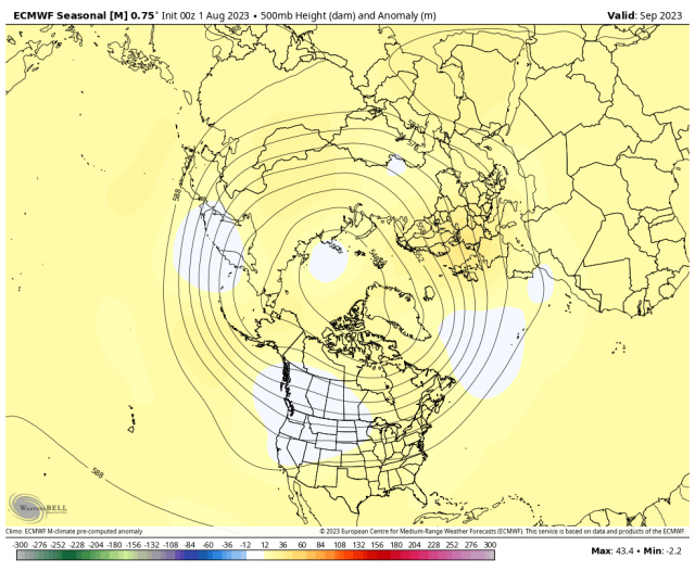
The Sea Level Pressure pattern forecast certainly supports it:
The northward shift in the model makes sense compared to the analogs because of El Niño trying to limit features in the Caribbean. So our forecast map is assuming September is going to be a big month. Again the PSU rule of August 15-October 15 is unlike last year, centering the season in the middle. Last year we picked out analog/model correlations and nailed the late-season activity. It will be interesting to see if this is correct.
The spread of landfalling majors in these years ranges from Harvey on the western flank in 2007 to Carol and Edna in 1954 to the east (Juan if you count 2003 in Canada).
It is interesting to note how the last three seasons have worked versus this one. 2020 was a wild start to finish. 2021 was early and 2022 late. This one is in the middle. So this turns into a "bang for the buck forecast". I have upped the majors to 1-2 hits. If there is a spray of 5 or 6 storms impacting the U.S., three or 4 hurricanes, and 1-2 majors it would mean the Power and Impact points would be higher, so I nudged that up.
The Verdict
The western Pacific is performing according to plan. I think 75% of the ACE may occur in September, and there may be a flurry of activity, depending on the MJO, similar to what we have seen before where several storms impact the U.S. all at once. The Texas hurricane season should shut down in October, and I suspect after October 15 the rest of the U.S. will too, but who knows what will get named out in the middle of nowhere that may head for Europe?
This is actually a pretty threatening impact forecast. We need to watch the MJO. So far we have been saved by western Pacific activity, as development there usually means the Atlantic is quiet. They are way ahead of the game this season. The quiet in the Atlantic is not likely to last, and there is a chance that the current quiet will turn into a riot for a few weeks, So far there is nothing on the horizon but rumors of storms, but later this month and especially in September, that should all change.
Note that next year may be a doozy of a season. I believe this is a bounce back El Niño in response to the longest and strongest MEI El Niño on record, so we should collapse it and go back to a La Niña base state. SSTs will remain warm, and so that may be a season number-wise (at least for totals) two times higher than this year.