250 Billion Dollar Storm 8 years ago
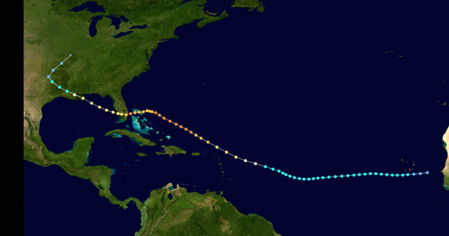
In my opinion there are two candidates for a future $250 billion storm. The first is obvious, New Orleans. New Orleans escaped the worst of Katrina because the storm path deflected most of the storm surge east of the city. However, there has been a storm path that could be the prime track to cause unspeakable damage to New Orleans. The Fort Lauderdale Hurricane of 1947...
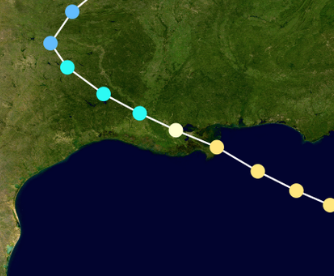
Zoomed in look on Louisiana...
However, after striking South Florida the storm never regained the kind of intensity it had. This is a common situation with well developed storms that strike land. The inner core gets disrupted, and relative to the entirety of the storm, the inner core weakens much more than the outer bands. When the storm emerges over the water the inner part of the storm competes with the outer rainbands which makes it very tough for the hurricane to regain its strength. Storms that are not yet mature, such as Katrina when it hit South Florida, are still developing and heading toward, not away, from the area for most favored intensity. Storms like this have no problem coming back over water and quickly reorganizing since their inner and outer cores are not mature yet. In this scenario, the inner core will weaken much less than if it was already a powerful hurricane. In any case, if the 1947 storm had hit South Florida as a weaker hurricane and then came back over water and reached its peak intensity as it was heading into New Orleans, it would have been a disaster. The angle of attack from the east-southeast means the full storm surge gets funneled back into Lake Pontchartrain and then into New Orleans. The 9-13 foot storm surge seen in Katrina would go to 20-25 feet. The wind would be higher as well. One has to understand this is not a matter of arguments over Global warming. We have the example, the question is not, why should it happen? But why won't it happen?
New Orleans is the obvious scenario, but the second one is not as obvious. However, the 1933 hurricane and Sandy should make it so.
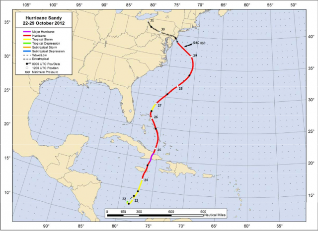
In 1933, the eye of the Great Chesapeake Bay hurricane hit far enough south so areas that were hit directly by Sandy were spared the worst.
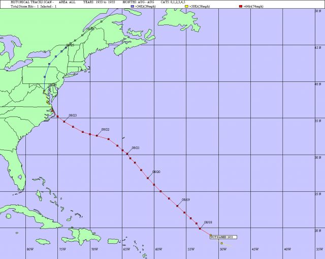
This was an immense storm with hurricane gusts all the way to Long Island. Isabel, too, was a scary path...
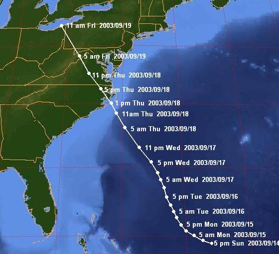
Take these two tracks and superimpose them further north, so that the hurricane is going in just south of the mouth of the Delaware Bay. Guess what can happen?
First of all, the biggest danger would be if the storm stalled for a couple of days. This would continuously push water back into the coastal areas where tides are well above normal. Now think about Sandy. What if Sandy went in 75 miles further south?
The affects around Long Island and North Jersey would be close to the same. The water would still pile back and the expanded gradient and fetch would mean the same kind of wind, surge, and waves in the areas that were devastated further north. Relatively speaking, Atlantic City, south of Atlantic City, and the ports of Philadelphia and Wilmington were spared.
Sandy also came late in the year.
Given where the Gulf Stream is usually located at the height of the hurricane season, a storm attacking from the southeast over very warm water with the big high pressure to the northeast would have little time to weaken.
Before I go on, why not New York City?
It is possible but consider the following. The water off New York City is not as warm as just east of the Delmarva, so a storm approaching New York City from the southeast would pull a lot of air in from New England and the waters east of New England, and finally it would mean the areas further south escape again. So a storm trying to attack New York City would have more time to weaken as it approaches, and the other areas that could add to the damage total would escape.
Here is what could happen further south. Heavy rains, if they precede the storm, in the Delaware river basin swell the now dammed-up lakes. People do not seem to understand that the lakes that were not dammed up in the 1930's are now. If water is released in tandem with heavy rains, it would lead to even more of a flood surge coming down the Delaware.
In the meantime, the hurricane making landfall on the Delmarva drives the core of its storm surge up Delaware Bay. It is bad enough the Delmarva is a decreasing area to put increasing amounts of water. What happens when the swollen river waters meet it? You are talking a disaster of unspeakable proportions. In addition, the arc shaped beach around Atlantic City would likely double or triple what Sandy's surge was there because instead of the core being north it would be right into Atlantic City. In this event Atlantic City and south are in the conversation for disaster. If the storm hit Ocean City Maryland to Rehobeth Beach, it would also likely lead to the disaster there.
Like New Orleans, the question is not why it should happen, but given past tracks and the idea that certainly in the course of nature a storm could go in between the areas described, why should this not happen?
I wrote about this years ago in something I called the Philadelphia Story, and I am writing it again. It is logical to expect that in the course of natural events this could happen, and I argue it should happen based on historical data.
"Extreme?" I think the quote is from George Bernard Shaw. Nonetheless, when it comes to weather, it is applicable.
Some men see things as they are, and ask why I dream things that never were and ask why not?
Except in this case it does not take a lot of dreaming to see what can happen.