2014-15 Winter Outlook 11 years ago
June 22, 2014
- ENSO 3.4 is the likely dominant warm pool, which is different from NOAA's blending of all ENSO events. These Central Pacific dominant events are known as Modoki El Niños.
- No "Super Niño" is going to occur as has been rumored.
- The weaker the El Niño winds up being, the faster the start of winter.
The most recent examples of what is now referred to as a "Modoki El Niño" are 2002-03 and 2009-10, although it's something many of us knew and understood well beforehand (we just didn't name it, but the idea of a warmer NINO 3.4 than NINO 1 & 2 was used by Joe D. and I even though we were not working together at the time to forecast the cold winter of 2002-03). These are most likely after prolonged, or major negative MEI conditions. These were common in the cold phase of the PDO of the 1950s-1970s, which we are also in now. The MEI and PDO will spike for a year or so, but then return to colder. It many imply, by the way, that the winters of 2015-16 and 2016-17 will be more western U.S. oriented for cold and snow.
This was first issued back in March:


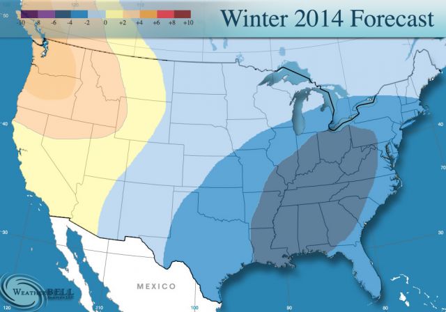
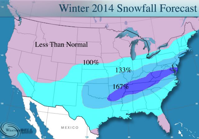
Again, as of now it looks like December should not be rip-roaring cold, and the winter will set in strongly January into February. The challenge is twofold: (1) does that warming occur and (2) if it does, does the winter then come on strongly? 2009-10 was a "winter's over" winter too, if you remember as after the Dec 2009 snowstorm there was a great cry for winter to be over. I even had a client tell me in no uncertain terms on January 15, 2010 that it would not snow in D.C. for at least 3 weeks. That was laughable, given what happened, but it reflected what was a common thread at the time. In the fog of the past, a lot of people don't remember the pressure that developed in the middle of the "snowmageddon" winter, but I certainly do given the sleepless nights in front of that.
I think we have a good blend idea here. Joe and I felt strongly about last winter because we had a real unique analog package with 1917-18 and 1993-94 (both had El Niños after and if I see this one more like that, I will factor them in). I was out in July 2009 with the idea for the 2009-10 winter.
By the way, the Super Niño talk was really a problem for a lot of us. The IRI plume forecast is even weaker than the examples up here, more like the 1976-77 ENSO event which was brutal in front. The weaker this is, the more it may be cold right out of the box in winter.