Winter 2016-17 Forecast Update 8 years ago
September 29, 2016
- Return of Nanook of the North on the table
- Warm PDO ring should re-establish major cold over East and into Plains late
- Warm West
- Higher than normal uncertainty about when winter will start in earnest
- Winter probably will start on time
- Still think January-March will be colder than November-January
- Analogs are colder than our forecast (for now)
- No change from previous forecast
- Added some CFSv2 and UKMET model comments
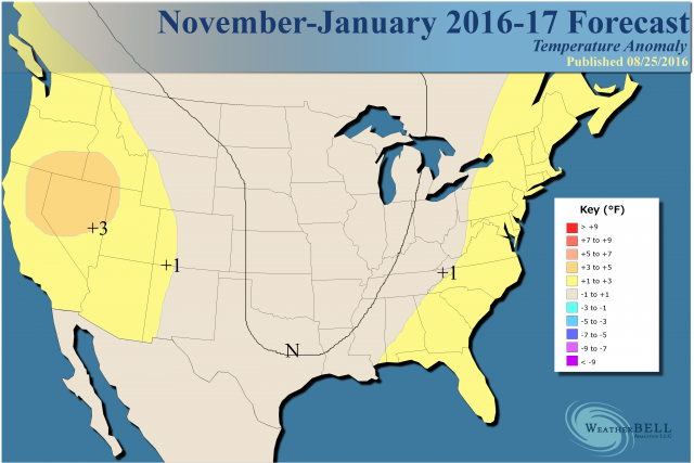
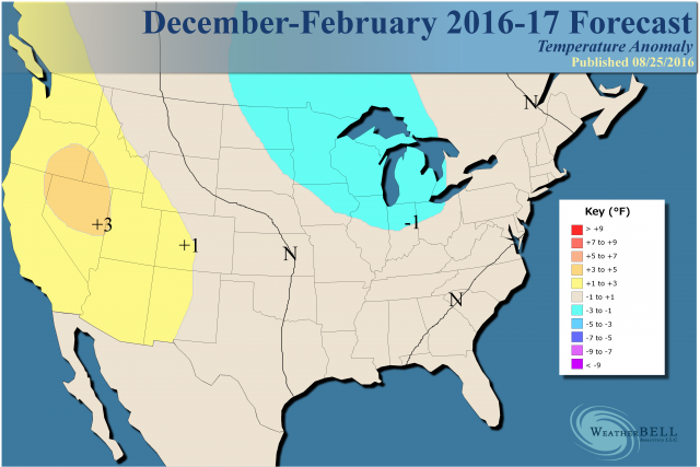
This is what the first half of the winter season is expected to look like:
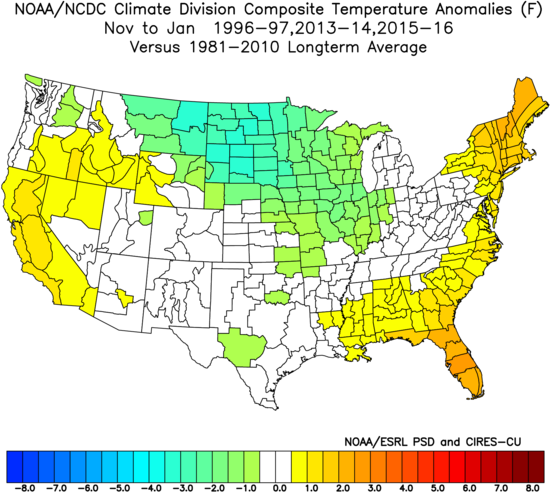
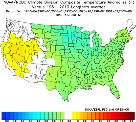
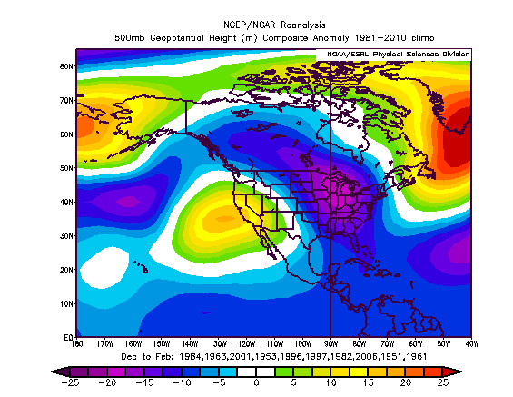
Sensible analog for November-January:
Model Summary
The 500 mb SST analog chart now goes out to December:
.gif)
SST forecast:
.gif)
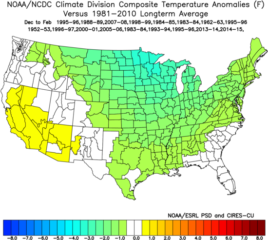
Temperatures:
.gif)
The UKMET model has a winter forecast out now. Here is its 500 mb pattern with troughs over eastern North America, western Europe and the Far East:
Temperatures:
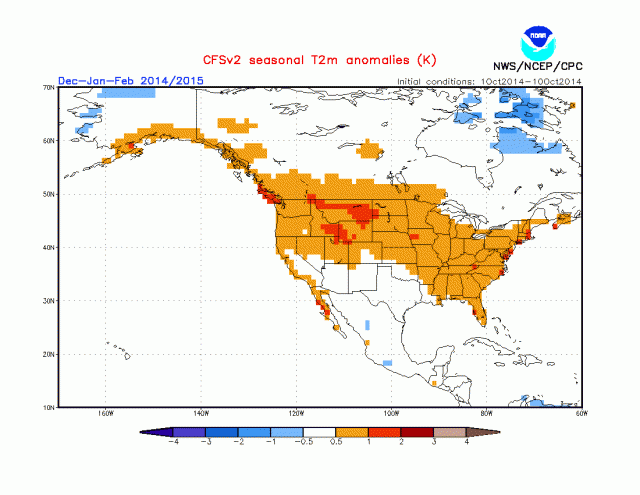
In the meantime, the CFSv2 has this at 700 mb:
.gif)
This is its temperature forecast:
.gif)
This is impressive, given the it was erroneously forecasting a ridge over the East prior to the onset of the last two cold winters.
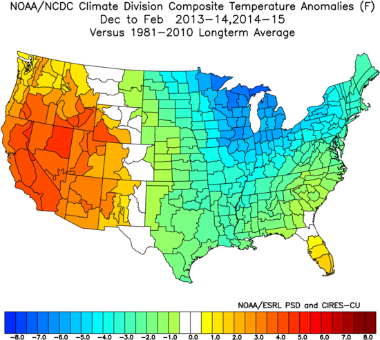
Forecast for 2013-14:

Forecast for 2014-15:
Those winters wound up like this:
Forecast Discussion
This is the forecast for the heart of the winter:
The uncertainty is when the cold will start in earnest. There is evidence both ways.
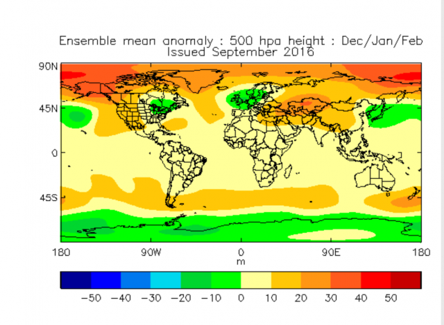
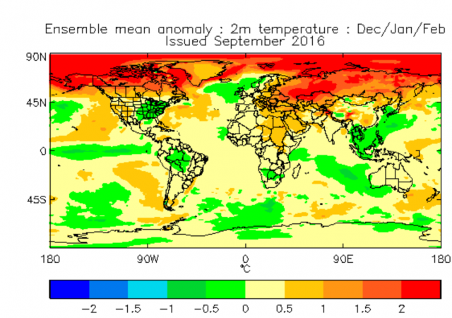
With the El Niño gone and the La Niña feeble at best, it gives what drove the cold winters of 2013-14 and 2014-15 a chance to overpower the pattern again. Such things as low solar and the state of the QBO are factored into the WeatherBELL Pioneer model, which has this for the winter:
This is very close if not on top of the Euro's implication for winter, which in the cold winters has been incapable of showing actual cool but instead will develop large areas of normal.
Here is the blended analog at 500 mb which looks similar to what the SST analog is hinting at:
This shows a lot of blocking, as does the Euro.
The combined analog from all the forecasters using the idea of independent consensus:
Among us, Tom Downs had the best blend for the El Niño last year. This time, 1995-96 was common among all three forecasters using their favorite methodology. 1983-84 also showed up. Those years had warm eastern Pacific rings, but the western Atlantic was cool. The western Atlantic is very warm now and early in the year, it tends to add to the eastern ridge. As the air masses into the center of the nation get colder, the western Atlantic simply acts like a magnet, as continental cold produces sinking air while warm water is a source for storms. So, the cold wins out and if there is enough blocking it can become quite severe (as we saw 2013-14 and 2014-15).
I remind you that we had a shot of cold into the East last year that produced a -1°F reading in New York City, unheard of in a strong El Niño with no snow on the ground. The problem is the cold after the first three weeks of January could not hit and hold, but went back and forth. After the warm December, the results were skewed because how warm it was in the first month of the winter. Now, without that El Niño involved, the infamous warm blob (that we jumped on in 2013-14) is still there:
.png)
As far as La Niña, it's going to be interesting to watch this, because the CFSv2 has had some wild runs. Some have been cold and others like its most recent, has an El Niño. The IRI plume continues to echo our suspicions this La Niña will be weak at best:
.gif)
The point is this is not going to be a big La Niña, and the kind of features that lead to cold and snow have a chance to take over this winter like 2013-14 and 2014-15.
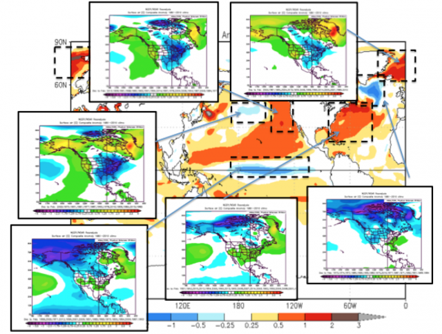
That being said, last year's star, Tom Downs, has reservations about the warmth of the Atlantic (as do I). The argument from Tom is that there could be warmth into January like 2014-15 (remember "Deflate gate" was near 50° in the second weekend in January). This chart from our meteorological Moses, Joe D'Aleo, shows the worry about what the different major SST features can give, given the SST forecast on the NMME model:
The forecasted North Pacific SST pattern tends to bring a warm West and a cold East. However, the western Atlantic SST pattern tends to bring a warm East. The Pacific looks opposite to what it usually looks like when the Atlantic is warm! The cool pool in the central Pacific and the warm Pacific ring usually give a frigid eastern winter. The central Pacific La Niña with a western Atlantic warm pattern tends to pump the ridge in the Southeast. So we can't go as cold as we see in the analog years.
The "sensible" analog:
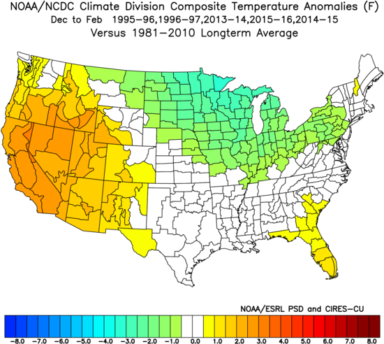
The back half of winter, January-March, is expected to be colder across the East.
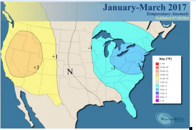
For January-March, I doubled the pure analogs, and I threw in 2012 and 2014:

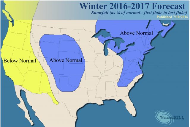
Snowfall
The snowfall outlook remains the same (first to last flake) as the one issued in July:
The Verdict
We are concerned that winter is going to get underway during the month of November, at least in a back and forth fashion. The JMA model sticks a trough over the Northeast in December and there is plenty of concern about that. For now we are focusing more on December than November as the "start" of winter. I still love our overall idea but hope to home in on how quickly cold comes in by the middle of October. In the end this winter will be more like 2013-14 and 2014-15 as far as centering cold over the East and Midwest and not across the South. There is low probability of the core of cold being in the West.