Preliminary Winter 2016-17 Forecast 9 years ago
July 13, 2016
- La Niña in trouble, more likely neutral
- SST analogs of warm PDO, Warm AMO, neutral ENSO most closely match 1958-59, 1959-60, 1993-94
- I am concerned about 1995-96 in the bunch too
- Essentially same look in northern hemisphere SST, minus strong El Niño
- Hangover of warm summer into fall may mar first part of winter.
- Huge disagreement with analogs vs models.
January-March:
For snow this year:
.jpg)
First let's discuss the analogs versus the forecast SST modeling.
The ECMWF has come out and killed the winter La Niña, much like we have been seeing recently on the CFSv2, though there are runs that have it. Scripps remains very cold, but is not as cold as it was. The SST analog, which never was impressed with the La Niña, continues unimpressed.
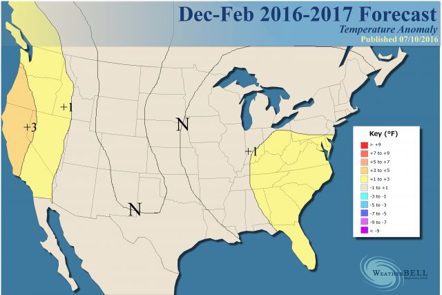
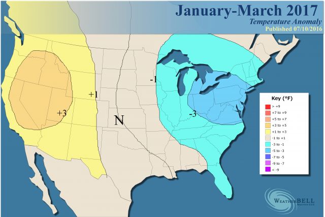
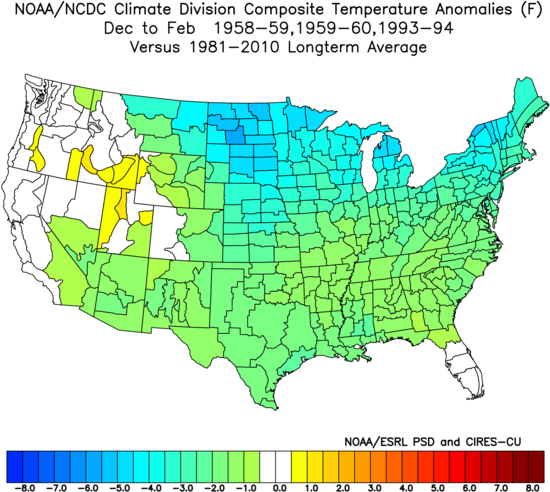
There are two reasons I am pulling back on the La Niña. 1) Low solar. The fact is that La Niñas do not like to occur in low solar periods. I have my reasons for this, which I do not wish to bore you with here. 2) The warm PDO. It is tough to get a La Niña with a warm PDO. Decadally, we are very close to the late 1950s and early 1960s. The huge 57-58 El Nino hung in till the spring of 59, though much fades. In addition, we have a warm western atlantic (warm is an understatement). This will "fight" cold early, but as the seasonal shift in the jet occurs, feedback favors the cold coming into the east as the winter progresses. So my bottom line is the endless summer we have been talking about fades into a warm fall, with the first shots of cold in the Plains and Rockies having to fight their way east. December is up for grabs, but January-March looks cold to me over the east and Plains. Taking in the last 2 Decembers I think its quite warm, but may flip.
So we have the late 1950s analog and guess who else? I like '13-'14, '93-'94. 2013-2014, of course, had a fast start . The scary thing about the analogs is that they are so darn cold.
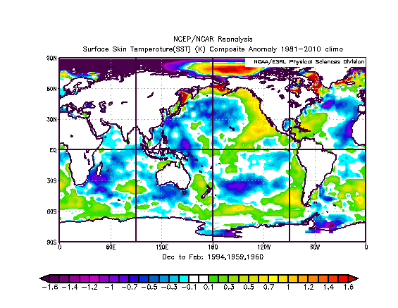
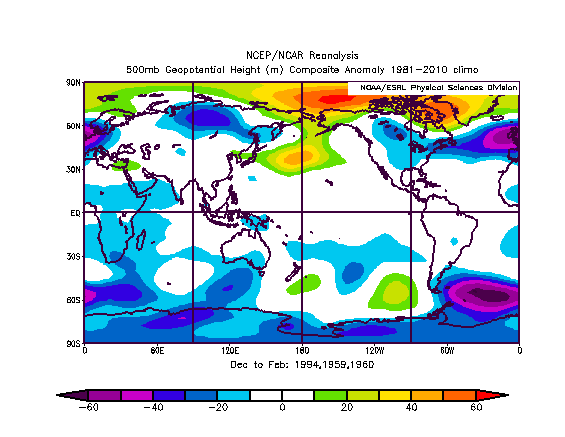
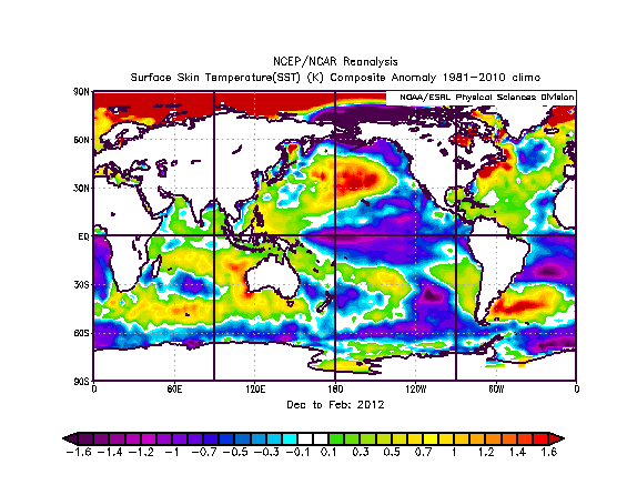
Let's look at what I am seeing. It was painstakingly tough to get a map match, but look at the SST analogs of those years:
Now we look at the various models.
CFSv2:
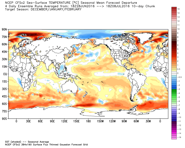
In the northern hemisphere that is a darn close match, and the euro looks a lot like it in its November-January period.
The SST analog has this, granted only out to December:
.gif)
The match is closer to the CFSv2 in the Atlantic with the cold AMO, but in the Pacific both are terrific.
By the way, we really scored a big coup with the cold winter in 13-14, jumping all over '93-'94 and '17-'18 analogs. But the '93-'94 SST is actually the closest of all three.
.png)
Now here is the big problem: we get this for the 500 mb blend for the winter analogs:
It looks like this is where the SST analog wants to go, blocking (this only out to Oct-Nov-Dec):
.gif)
There is a big argument in the Pacific, though!
The CFSV2 catches the Pacific trough right in the sweet spot for an eastern trough, but then has a big ridge over the east with a trough in Europe. This makes no sense!
.png)
So the blend of the two models would lead me to believe that we will have a ridge to start, but it will get crushed as winter goes on. The major warm PDO takes over, fuels a western ridge in the means while the foe (feedback in fall to early winter pumps the ridge near the east coast) turns friend (storm track and the fact a colder central US loves to fight and then win over the east in a warm PDO) mid and late winter. Even last year it tried and there will be no raging low pressure through much of western Canada this winter with no El Nino.
So I am confident that the winter is overall more bullish temperature wise than last winter or, for instance, 2011-12. Please remember last year there was a panic in the energy market in January though it could not hit and hold, after the blow torch December. But the Pacific SST for the dreaded '11-'12 looks nothing like the modeling this year.
The Atlantic does, though, and I think, given the warmth of the next 5 months, there will have to be a fight.
So how can we do this?
- November below normal (CDD/energy usage)
- December still below normal
- Jan-Mar above normal
The pure analogs are out of control cold and I have to split the difference with the modeling, in spite of not trusting the modeling.
December-February:
January-March:
.png)
To get you a sensible analog, which would serve for now, I need to throw in warm ones to blend. So the winter sensible analog, to get the temperatures I want because of my December-phobia (threw in the offending year of 2012 to get there) are:
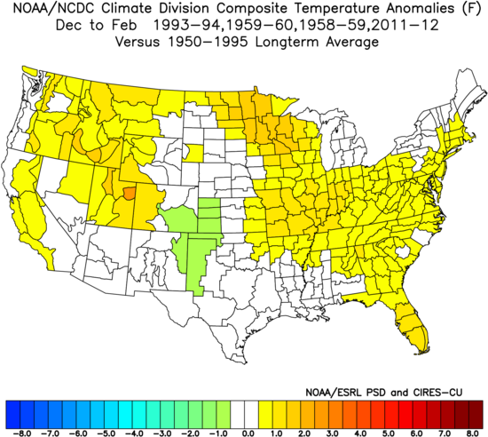
For January-March, I doubled the pure analogs, threw in 2012 and 2014:

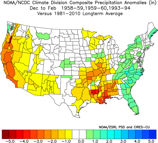
The warm western Atlantic means a lot of precipitation there, and the central US where early fights can occur:
Verdict: A late starting winter is our call now.
- Potential for major cold in January-March, but the balancing act is the warm start. December has been a tough month last few years, and I can see arguments for cold and warm.
- I think we have a winter that will flip, but unlike last year, it will be cold for a large area with high energy usage.
- Big snow year in the east again, bit more widespread back toward the Lakes. The Plains look above, but the Rockies for hydro concerns, looks below.