D'Aleo- The Great Appalachian Storm Of 1950 14 years ago
We have in recent days presented info on northeast snowstorms since 1956 as compiled by NOAA. An historically savvy commenter remarked about the La Nina super storm of 1950. Here is a desciption of that legendary late fall storm. These facts were compiled from recounts by Ohio Online, the WOOD TV blog of Bill Steffen and the NWS office in Jackson, KY where the storm is still remembered by long time residents to this day.
The so-called "storm of the century" hit the eastern part of the United States, killing hundreds and causing millions of dollars in damages, on Thanksgiving weekend in 1950. Also known as the "Appalachian Storm," it dumped record amounts of snow in parts of the Appalachian Mountains.
Forming over North Carolina just before Thanksgiving, the storm quickly moved north, striking western Pennsylvania, eastern Ohio and West Virginia. These areas were blanketed with several feet of snow for several days and travel was impossible for nearly a week in some places.
An accompanying windstorm covered a far greater area. New York City recorded a 94 mile-per-hour wind gust. At Bear Mountain, just north of the city, a 140 mph gust was recorded. The winds throughout New England were of hurricane-like force. In addition, high tides and wind-driven surf battered the coastline. On the south edge of the storm, record low temperatures were recorded in Tennessee and North Carolina even without the wind chill. In Mount Mitchell, North Carolina, a temperature of 26 degrees below zero was recorded.
The storm was unique, however, because it featured not only extremely strong winds and heavy snow, but both record high and low temperatures. In Pittsburgh, 30 inches of snow fell in a blinding snowstorm. Further north, Buffalo saw no snow, but experienced 50 mile-per-hour winds and 50-degree temperatures. Paul Kocin, a Weather Channel expert, has said that this storm "had the greatest contrast of weather elements in probably any storm, including the 1993 March Superstorm."
The extreme weather was deemed responsible for the loss of 160 lives over several days.
=============================================================
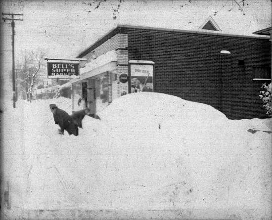
The Thanksgiving snowstorm of 1950 was the deepest in Ohio’s history. Nearly the entire state had over 10 inches and most communities in the eastern half of Ohio measured 20 to 30 inches of snow during this storm. As the storm strengthened, winds increased to over 40 mph and a severe cold wave swept the state early on Friday November 24 th dropping temperatures to near zero. The worst storm conditions occurred on Saturday November 25 th as near-blizzard conditions prevailed throughout Ohio. By late in the day, snow depths reached 20 inches in eastern Ohio and drifts were 25 feet deep.
The classic Ohio State-Michigan football game was scheduled for Saturday afternoon in Columbus, the Big Ten championship and a trip to the Rose Bowl on the line. So with a Saturday morning temperature of 5 degrees and winds of 40 mph, the “Blizzard Bowl” was played in Columbus. Bill Steffen on the WOOD-TV blog describes the event.
On Nov. 25, 1950 Michigan and Ohio State met for what has been called the “Blizzard Bowl” or the “Snow Bowl“. Check out the film of the storm here and here. Michigan won the game 9-3 despite gaining only 27 yards of offense in 46 plays. They had no first downs, didn’t complete a pass and punted 24 times. In fact there were 45 punts in the game. Both teams mostly tried two runs then punted on 3rd down. Only 2 of the 45 punts were returned (for a total of 8 yards). Most just hit the snow and stopped without bouncing. There were only 10 fumbles in the game.
The temperature at the start of the game was +10° and the wind was howling out of the north-northeast. One Ohio St. player remarked that he was supposed to go down and block a linebacker, but when he ran downfield he could find him! All the points were scored after blocked kicks in the first half. Several hundred Boy Scouts were on the sidelines helping to sweep snow off the field so the officials and players could find the yard markers.
Most of the state of Ohio got 10″ or more of snow, with reports up to 33″ and drifts up to 25 feet! The temperature in Grand Rapids that morning reached -10°F, the coldest temperature ever recorded here in the month of November. (photo – OSU library)

The storm continued through Sunday and by Monday morning, snow depths reached 33 inches at Steubenville, 30 inches in Geneva, and 29 inches at Youngstown. Bulldozers were used to clear roads so that ambulances could reach those in need. The Ohio National Guard used Jeeps to transport people to hospitals and to deliver food to rural homes. Wires and trees were blown down by winds as high as 60 mph. Many buildings collapsed under the weight of 2 to 3 feet of snow and much deeper drifts.
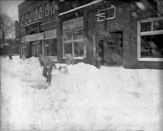
Digging out in Massilon, Ohio (above and below)
---------------------------------------------------------------------------------------------
In Kentucky, the storm was one of the most damaging and meteorologically unique winter storms to strike the eastern United States occurred on Thanksgiving weekend 1950. After it was over, up to 57 inches of snow blanketed the central Appalachians and one of the most widespread and damaging wind events ever recorded over the Northeastern U.S. made the Great Appalachian Storm of 1950 the costliest storm on record up until that time.
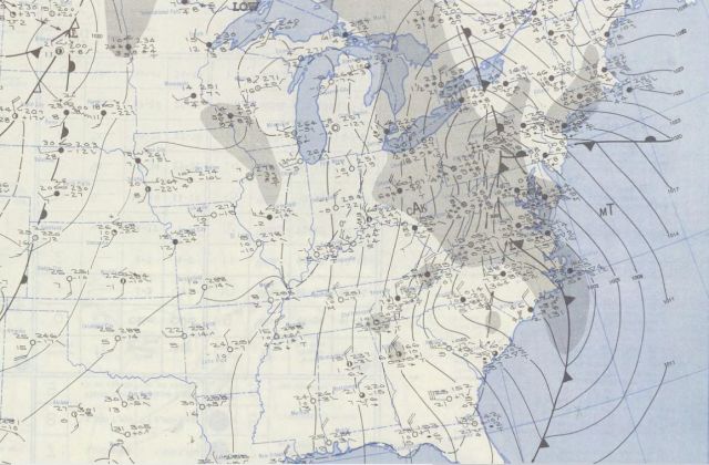
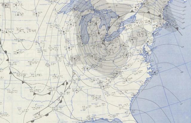
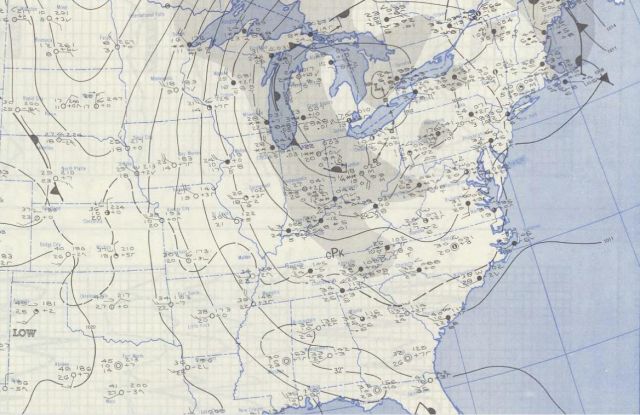
Timeline
The precursor to the storm was the passage of an arctic cold front late on the 23rd into the 24th. The front passed through eastern Kentucky around midnight and the change in airmass was dramatic. Temperatures plunged from the 40s and 50s just ahead of the front to the teens just behind it. A thin but heavy band of snow accompanied the dramatic temperature drop behind the front with as much as 7 inches falling across southeast Kentucky on the morning of the 24th.
The record setting arctic airmass behind the front sent temperatures to all-time monthly lows across the Upper Midwest and Ohio Valley. Chicago dropped to -2ºF on the 24th equaling their all-time monthly low, and a day later Louisville (-1ºF), Lexington (-3ºF) and Bowling Green (-7ºF) all recorded record lows for the month. Temperatures across eastern Kentucky by the morning of the 25th were in the single digits and teens, and still dropping.
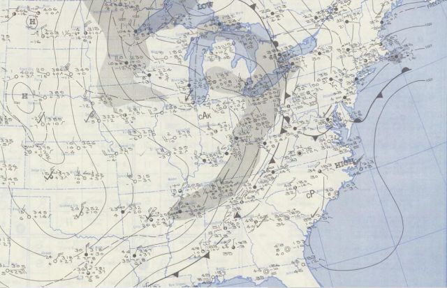
Low pressure quickly developed on the arctic front over the Carolinas on the 25th. The low tracked northwestward into Ohio by midday on the 26th with a shield of heavy snow expanding back to the northwest as it did so. The storm slowly wound down as it spun in place over Lake Erie on the 27th and 28th before it finally weakened and exited into Canada on the 29th and 30th.
Surface maps are included below for each day from the 24th through the 27th.
Impacts
A unique feature with this storm was the wild temperature gradient produced as the arctic airmass wrapped southeastward around the low, while warm air from the Atlantic was pulled northwestward.
Case in point, Pittsburgh, PA received 30.5” of snow and recorded temperatures in the single digits while only 200 miles to the north, Buffalo, NY enjoyed temps in the 40s and recorded no snow at all.
Intense winds buffeted the East Coast into New England. New York City recorded a peak wind gust of 94 mph and Newark, NJ recorded a 108 mph wind gust. A 140 mph gust was recorded at Bear Mountain, just north of the New York City, and winds gusted up to 160 mph on Mount Washington, NH. The intense winds caused extensive tree damage and power outages and whipped up surf on the beaches.
The resulting coastal flooding breached dikes at LaGuardia Airport in New York flooding runways. Heavy rains on the warm side of the system brought near record flooding to eastern Pennsylvania.
By the time the storm wound down on November 29th and 30th. 160 people were dead and insurance companies paid more money out to their policy holders for damage than for any other previous storm or hurricane.
Across eastern Kentucky, several days of snow added up to over a foot in many areas. Paintsville recorded 14”, Hazard and Manchester 13” and Pineville received 11”. Bitter cold also gripped the area with most locations recording temperatures in the single digits to near zero on the 24th and 25th. Middlesboro bottomed out at 3ºF, Williamsburg 1ºF, Farmers 0ºF and Somerset –2ºF. All but the 0ºF reading at Farmers still stand as record low temperatures for the month of November.
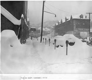
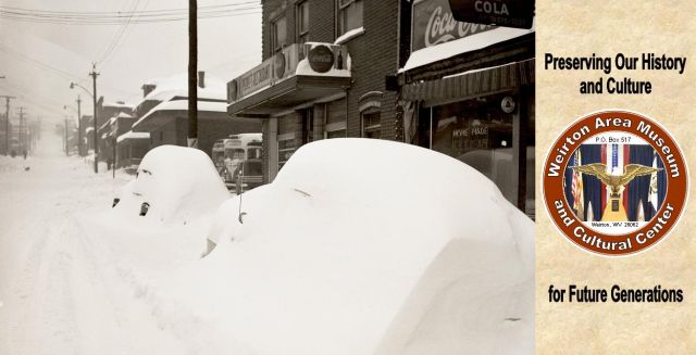
In West Virginia, snow was mesured in feet. Here is Weirton, WV.
Note: 1950 is one of our analog years this year.