Final Winter Forecast 9 years ago
November 30, 2016
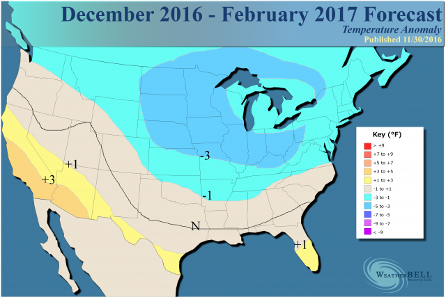
- Colder than normal winter for much of U.S. from the Plains eastward.
- Forecast relies heavily on our analogs, the WeatherBELL Pioneer model and the path we have been on, which has been largely correct since last spring.
Analog:
.png)
There are no changes to the snowfall forecast from last issuance:
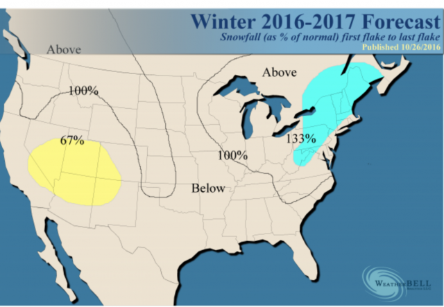
Our snowfall forecast is relying on the cold to produce both Lake Effect and large scale storms over the interior Northeast. The big news is that the core of the heaviest snow is back to the northwest but the big cities should be above normal anyway. While there should be a southwestern ridge, there is likely to be enough coming through the ridge to enhance snows in the Pacific Northwest into the High Plains, where we think precipitation will be above normal overall.
In July we thought winter would be late but have moved it forward, worried about the change coming sometime in November. While there is no question this has resisted more than I thought from October, the last time this kind of outrageous imbalance between Asia and the U.S. occurred was in January 2006. The cold came to the U.S. in February then, but the major difference was that we were backing out of winter.
North America is a small continent compared to Asia, and we are surrounded by warm water. It takes longer for the imbalance caused by what is a boiling arctic to show up over our continent. As the seasonal jet shifts (remember cold loves to displace warmth - while the arctic is warm, it's farther to the south where it's really warm and not just above normal since normals are high). So what you are seeing is the cold sloshing to our side of the pole, the simple process of cold trying to replace warmth aided by the change of seasons. At the very least, we now have to deal with a frigid pool on our side of the North Pole. From where I sit, while admitting that timing is always tricky, it looks like at the very least December will be a big hitter.
This forecast on the Euro model for Days 8-13 is outrageous (850 mb or about 5,000 feet):
.png)
It has been getting colder over the past couple of days when it was like this for the same period (this was plenty cold anyway):
.png)
So at the very least there is cold threatening. I believe this can be likened to a prize fight where one fighter comes off the ropes and starts chopping down the other. Eventually the other is going to fall. I will make no secret of the fact I did not discover the bathtub slosh theory but picked it up from people older and smarter than I.
So I am leading this off because our team, while not perfect, has come off the disappointment of last winter, which December blew up, and the cold could not hold in January for more than 3 weeks. So I am relying strongly on the WeatherBELL Pioneer model. That model looks like this for the winter:
You can also see a cold winter forecast for Europe, too. This is analogs, minus antilogs, where the year listed is the latter year in the winter (example 1962 is 1961-62).
The final maps are the blend of analogs that the team has come up with and is very close to this.
It's interesting in that the methodology we use is Independent Consensus. It produced the years 1983-84, 1995-96 and 2000-01 as the strongest. I am throwing in some decadal winters because I feel we are very close to the same kind of Pacific pattern after the 1957-1958 El Niños and the three winters before last winter, which had significant late season cold. This leads to some interesting "arguments" as some anti-logs in the WeatherBELL Pioneer model are actually favored by one of the forecasters (me) as an analog - that winter being 2014-15. By and large the analogs that the maps are based on and the much more advanced WeatherBELL Pioneer model (which looks at 21 variables including terrestrial features and solar activity) come out with a blend that does not go all the way to the kind of severe winter this could turn out to be. However, it continues to show a cold winter with more worry about a colder option than it turning quite warm.
That does not say the warm ideas do not have a home here. We are well aware of them. We feel as the winter goes on, the big five teleconnections of the WPO, EPO, PNA, AO and NAO, while at war with each other, will break more strongly more often for their neutral or cold phases than the warm phases. The cold tongue in the Pacific shows up in the winters of 1959-60, 1960-61,1961-62 and each of those had some very cold periods.
In addition, antilogs to the cold tongue, such as 2001-02 and 2011-12 show up. So the forecast idea is one that sees how some of the warmer ideas out there can take over, takes into account modeling, but also weighs the colder options more than the warm ones. Again I am more worried about the severe cold options showing up than blow torch warmth like last year.
Here it is worth mentioning a word about the warmth of the globe. I believe this cannot be ignored, but where it's warm is where normals are coldest (the Arctic). This creates problems, for even if there is abnormal warmth, if it is not in the tropical Pacific source region the input (as far as the release of heat) is not as great, so the problems we encountered last year are just not there. In addition, last winter the earth was very warm and getting warmer. Right now, though still warm, it's cooling away from the El Niño. The last Super Niño followed by a weak La Niña (or cool-shaded neutral phase) was 1983-84.
One thing I will say about the models is that they almost all like a warmer U.S. winter, but do so with positive departures from normal over Greenland. That is a very hard thing to do. If the block locks, winter rocks.
December
.png)
Sensible analog:
.png)
January
.png)
Analog:
.png)
February
.png)
Analog:
.png)
I did not monkey with the temperatures (warm them a degree or two), letting the analog mix run in its purest form. There is the risk of extreme cold as we see in Asia, and so I felt that even allowing for a warm globe (addressed above) the atmosphere cannot tell what a +0.3°C global anomaly means for only one area. In fact, if most of the warmth (on the order of 5-7°C) was in the arctic, it would argue for colder elsewhere.
Cold is fighting to get here now, and that means it's not likely to flip back suddenly. For instance, in 2005-06, the SSTs in the Pacific (left) were opposite of this year (right):
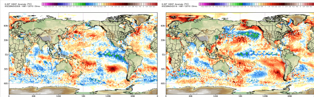
I still wake up in cold sweats over that January.
The Verdict
The forecast is cold because we feel the cold options will either fight to a draw or win most of the time. This would leave warmth only making brief appearances, most amplified in the Southwest and extending across the South. The feedback of the season, now that cold is coming into North America, is arguing for snow and cold to develop a partnership, as it's the right time of the year for that. In terms of other winters and the potential that is on the table, our forecast is tame, though most certainly at odds with any warmer ideas out there.