Anatomy of an Arctic Attack, December 29, 2013 12 years ago
December 29, 2013
Before I get going on the debacle that I think that will have to be dealt with in 7-10 days with severe cold that the GFS was poopooing on Friday, let me be clear on the storm this week.
THERE IS GOING TO BE A MAJOR WEST TO EAST DISRUPTIVE WINTER EVENT. This will be similar to December 13-14 in that an arctic boundary from the north needs to come through you for you to get into the heavy snow. It will be powdery and it will be a much colder event, partly because it is January. Now the problem we have is where does that true front get? I think it gets as far south as New Jersey to Nebraska and so the heaviest snows are likely from the Plains to the Appalachians between I-70 and I-80, and north of the Mason Dixon line to I-90 in the northeast, with the engulfing of northern New England, too, as the storm taps Atlantic moisture. I never thought this would be a Virginia storm or slink off to the south like the 00z ECWMF two nights ago. I also think the GFS is not strong enough. However, I can see the stronger/further north idea of the ECWMF, though at this time I believe the in between idea that I have is best. The problem is that the moisture will not get into the storm to get lifted unless it runs into the arctic dome, at least that is the problem I see until it reaches the east coast.. is it 2 or 12 in NYC, cant say quite yet but its not some shrinking violet. This is the kind of synoptic pattern that one can look in Kocin/Ucceline Snowstorm book and see: departing vortex with jet behind, and trailing short digging in with a double jet structure . So I am quite certain we have a big storm. I don't think it will be pushed south, never have, but I am uncertain as to where the true arctic front gets. But a lot of people are going to get a real dose of a darn cold, major winter storm.
I continue to be in awe at what I think is the modeling having a devil of a time with handling what is going on. That we have correctly diagnosed that the tendency for the ECWMF to pull back the ridge into the US after day 10 is a problem. So we can watch its ensembles go from this from the 00z Friday run for day 17:
.png)
to this:
.png)
With time, I think that ridge in the maritimes will correct north and there will be much more trough in the Lakes to the southern negative.
But its the abysmal 00z Friday GFS ensemble and its following follies, which lead to people thinking somehow all this blocking was not going to lead to a lot of cold, that I want to go after. Look at this day 11 from 00z Friday:
.png)
It corrected to this the following 00z run:
.png)
But it still has not caught up to the ECWMF, even with its 00z run last night:
.png)
But still much too much western trough.
So watch this the progression of the pattern and the arctic short wave, labeled (A) that does this, as it combines with a short wave from east of Asia (B) to lead to the arctic attack the coldest of the winter for many from the Plains east in the 6-10 day period.
Initial:

24 hours:

Let's move to 72 hours:

96 hours:

120 hours. Pay attention to the northern features, not the storm to the south, haha:

144 hours:


192 hours:

Finally, 216 hours:
.png)
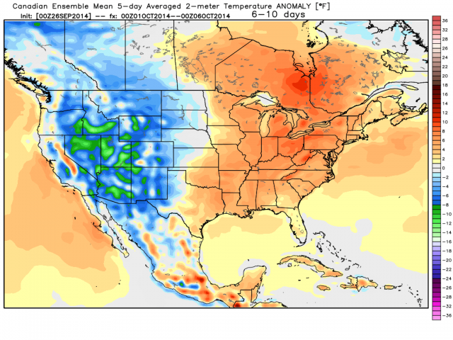
So the 6-10 GFS is much warmer looking than both the ECWMF and Canadian ensembles:
.png)
ECMWF:
.png)
Canadian:
So what is the conclusion?
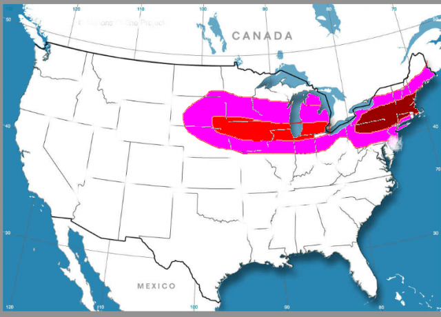
1) A big storm is coming, but the arctic front from the north will be the southern boundary of not so much rain vs snow, but snow vs almost no... so we have to see where that gets too and I think its New Jersey to Nebraska.. the low may track south of it along a a boundary that will have modified air, but its when it gets to the coast it will truly explode. That being said, the wicked cold to the north and powdery ratios will make it beg storm from in the lower Lakes, Midwest north of I-70 and plains a bit further north in a swath, but amounts in New England could double what they see out there. I am thinking a lot of 4-8 inches snows between I-70 and I-80 west of mountains and then increasing once to New England. I do not think this is a 4 inch storm for DC, I do think it is for NYC but am uncertain if they are in the 8-16 I think you will see close by The ugly brown is where I think that could occur on the map above.. the red is where max snows with high ratios are. I just want to be clear as to how I think this plays out. If the arctic boundary is further south, I will shift it south, but I don't think this is mid Atlantic snowstorm targeting DC or Richmond. I do think it's a big storm and along the lines of the type we saw in December, where you better get the arctic boundary from the north through for a 4 inch snow, though it wont be sleet and rain that holds it down, it will the overrunning being north of a site.
2) The arctic attack is on the way and is outlined above.
3) You have to be a nut case to be up at 2-4:30 on a Sunday morning to do a post like this. You can fight about the above 2 ideas, but this last one is beyond dispute.