2015 Hurricane Forecast 11 years ago
April 12, 2015
- There is no change to the totals from the March forecast.
- This updates tries to home in on the greatest threat area for this season.
Forecast
- Named Storms: 7-9
- Hurricanes 3-5
- Major Hurricanes: 1-2
- ACE 65-80% of normal
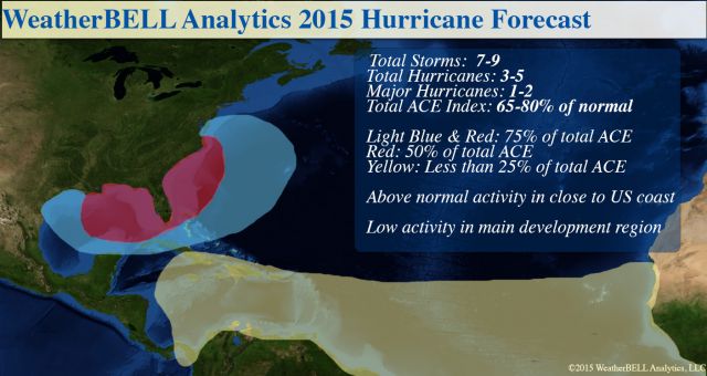
Note: Anything in the 50% has to be scored in the 75% too, so, that is the reasoning in the overlapping areas. The targeted area is shifted west from last year to include major energy zones. The lack of ACE in the Main Development Region is highlighted.
Discussion
Last year, the forecast centered the congregation of tracks near the East Coast. One landfalling storm, Arthur, was the strongest ever to hit that far north so early in the season, a testament to the warm water off the East Coast. The two major hurricanes (in fact all the storms except for Tropical Storm Dolly in the western Gulf of Mexico) reached their maximum intensity within the targeted area.
While not as good as the 2012 forecast, it showed far more skill than 2013's. That being said, the lack of activity in 2013 helped us track down the 1917-18 winter as a top analog, as there was an astoundingly close setup with the Pacific and Atlantic sea surface temperature patterns.
I am noting this because I believe tropical cyclones are in large part due to the entire global pattern. However, this year is one of those stand-alone type years because of the extremity of the warm water near the coast. The local patterns at the particular time when there is a development threat will be huge this year, rather than the large-scale pattern.
The overall pattern in the Main Development areas of the Atlantic is brutally hostile - warm water north of cold. The evolving El Niño is a big factor, but we have had El Niños like 1969 and 2004 that had big ACE years (this has to do with a 400mb mixing ratio theory I have, which I will not bore you with now).
This picture favors lower than normal pressures north of 25°N and higher than normal pressure in the tropics (negative features for tropical activity).
.png)
Some of the hostility in the global patterns can be seen currently over India. There, it is raining early this spring and this is forecasted to continue. This is not a sign of a healthy monsoon. Instead, it usually means the monsoon comes on late. To continue this missive, if we assume that each year, there are a certain amount of tropical waves that traverse the tropical oceans, the cool water in the Southwestern North Pacific (with warm water in ENSO 4) implies a great deal of convergence in the Main Development of the Western Pacific. A lot of westerly moving waves there will accomplish the "goal" of the tropical season (to correct hemispheric heat imbalances by moving energy from the Tropics to the Poles). A big Western Pacific year is in store, and this rarely pairs with a big Atlantic year.
However the U.S. is not in the Deep Tropics. A close-up of the U.S. coast reveals big problems with the SST pattern:
.png)
Gulf of Mexico:
.png)
That looks like a great Gulf of Mexico warm "Loop Current" and that is a signature for strong storms there.
So far this year, the Western Pacific ACE is off to the fastest start since 1958. That is the big problem for me. Hemispherically, the closest overall pattern this year in both the Pacific and Atlantic is the late 1950s. In spite of the coming moderate El Niño event, 1957 produced Category 4 Hurricane Audrey in the Gulf of Mexico in June and the vastly under-known Helene in 1958 was a powerful Category 4 that came within 10 miles of Cape Fear (North Carolina was in the eyewall, but that is not a technical landfall).
Dr. Ryan Maue made a good point after Dr. Klotzbach (from CSU), who I think is great (we use the Gray/Klotzbach AMO), came out with an ACE forecast of 40. Dr. Maue said that one "fish storm" (big hurricane that meanders in the Atlantic north of 30°N and jacks up the ACE can blow that out of the water. He beat me for a steak dinner in 2012 because of three of them did that! That being said I can see 40% normal ACE being achieved (the ECMWF is 50%).
The WeatherBell forecast is 65-80% of normal ACE. The old man (me) knows 1957 and 1958. I know Audrey and Helene. Helene (1958) comes ashore and it's a legend instead of something many of you may have never heard of.
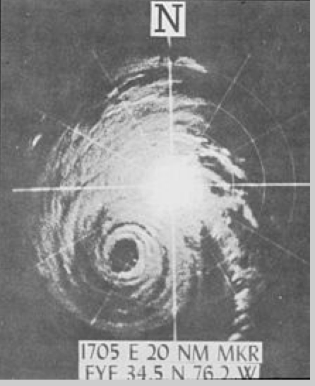
Look at that eye on Hatteras radar:
The Verdict
The huge message is this. Unlike last year, the Gulf of Mexico is open for business. I would be surprised, given the cycle we are in and the warmth of the water, if there is no major impact storm (by my scale) or major even by NHC's Saffir-Simpson scale this year. Once within 200 miles of the U.S. coast, the El Niño and harsh Main Development Region conditions don't mean anything.
I fear a scenario like the late 1950s. Audrey in the Gulf of Mexico and Helene in the Carolinas. There is no assurance you can't have two similar storms in one year, nor an assurance that one shows up and gets driven into New England. There is far greater confidence in the lower than normal idea farther to the south. The entire season may have us asleep 75% of time, but the 25% of the time we have to be awake, it may lead to great wailing and gnashing of teeth.
Final Note
I respect NHC immensely, as eyes that will be 60 yrs old in July see things different now. However, this is not the kind of year that they eat up with big, classic storms. That is not to say they won't do great. It is to say I will not be looking at them as some kind of rival, but advising you on what I see to give you the greatest advantage.
All weather is a vast, infinite and relentless opponent. That is enough to truly focus on.