Bastardi- Winter Starting to Show Up 12 years ago
January 9, 2012
The Euro weekly is interesting tonight, as the implications of the current strat warm are showing up in week 4. The current flip is coming from what happened up until now. However, keep in mind that it backs off and then recharges. My point is that the strat warm is arguing for a nasty February, and for the first time I am not seeing a Euro weekly with a week 4 blow torch. Interestingly enough, the period that is coming up over the next 2 to 3 weeks, had no sign of occurring 2 to 3 weeks ago. Previously, they had nothing but ridge, ridge, ridge over the East and it is obvious from later this week through next week, that there will be a trough in the East.
Another good sign is that where it was in the 60s on Saturday, it snowed today.

However, the precip has not been able to crawl up as far North. But, as one of my clients from Farifax, VA emailed me today when it was snowing there said, he thought the squat routine had fried my brain.
So now that the GFS is showing this for the Wednesday into Thursday event. Given what is going on today it is not so far fetched. Truth is, this should start the swath in the blue ridge and connect it through the Poconos, Catskills, and Berkshires of 3-6 inches of snow. But, the point is the model is now seeing it

What I don't trust is the coastal bomb in the longer term, as seen here with snow all the way to the Carolinas
The GFS predicated snow increase off of Dr. Ryan Maue's site shows this:
.png) \\
\\
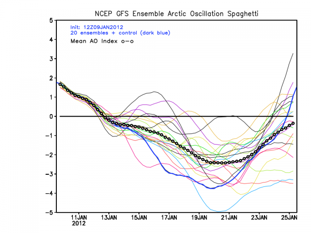
That being said, given that the AO temp charts look like this:

And the last 4 runs of the ensemble have looked like this for the AO:
00z:
.png)
06z:
.png)
12z:
18z:
.png)
I think we can all agree the model is seeing a flip.
Two more things:
First, a side issue. In mid May I said that the La Nina would return and would get to be weak to moderate, and then fade. In addition about a month ago, I said I expected an El Nino to develop in mid and late 2012. While I thought this winter would be a break relative to what the last two years were (so far more of a break, but we are not done), next year could be a doozy. The summer will not be as hot (more like 2009) and winter could last into April this year, centered on the Lakes. We also will not have as bad a tornado season this year. in fact, overall 2012 should not be near the year for mayhem as 2011 was. But that is based on where I think the ENSO is going. The CFS, which over the last 9 months has done everything from encouraging a Hansen Super Nino to then coming to a strong Nina is in my camp now, the La Nina has reached its low point.
.gif)
The second thing is the forecast for a drop in global temps to -.15 by march. The latest 8 day average is down to -.13.
.png)
Now all I have do is get you snow geese fed with at least something, and then we can all be at least a little happy
ciao for now